[Next Section]
[Previous Section]
[Table of Contents]
Full Equations (FEQ) Model for the Solution of the Full, Dynamic Equations
of Motion for One-Dimensional Unsteady Flow in Open Channels and Through
Control Structures
U.S. GEOLOGICAL SURVEY WATER-RESOURCES INVESTIGATIONS REPORT 96-4240
4.2 Directional Changes
The principles of conservation of mass and momentum are applicable to any flow, and simplification to a 1-D approximation is valid if the assumptions are met. These assumptions apply to linear channels that do not change shape rapidly. The classic example is the laboratory flume or a straight reach of a canal. A straight reach of a natural channel is an example of a gradual change in shape and a flow that follows a virtually linear path. However, many unsteady-flow model applications involve changes in direction of the channel. This change introduces curvilinear flow, which is a violation of the 1-D flow assumptions. This curvature is in the horizontal plane, however, and not in the vertical, so the hydrostatic-pressure-distribution assumption is still valid. The selection of the principle of conservation of momentum now causes a problem. This principle involves the momentum of the water and the forces exerted on the surfaces that confine it. Momentum and force are vectors, having both a magnitude and direction. Changes in direction can be as significant as changes in magnitude. Several questions need to be considered. First, is it valid to apply momentum conservation in a curved flow, ignoring the curvature and the nonhorizontal water surface in channel bends? Second, how should the distance axis be defined for a curved channel of varying size and shape? Third, how should the channel geometry be defined so that the equations are as simple as possible yet still retain physical meaning? For 1-D flow, distance and time are the only coordinates. Furthermore, the functions defined must be valid in terms of only distance and time. To properly integrate and differentiate with respect to distance along the stream, a reasonable definition of a distance axis must be established.
The definition of a distance axis includes mathematical and physical considerations. Mathematical considerations relate to the proper evaluation of integrals and derivatives. Therefore, careful mathematical and geometrical analysis will provide a definition. However, the effect of ignoring directional changes in the conservation of momentum principle is a physical question that only experimental results can answer. Miller and Chaudhry (1989) compared a physical-model result for a dam-break flood wave in a rectangular, prismatic channel with a 180-degree curve to the result obtained from a 1-D mathematical model that did not account for channel curvature. In this case, the definition of the distance axis was not a problem because the channel was rectangular and prismatic. For a prismatic channel, the distance along the centerline of the channel is the correct distance to use for the axis with the traditional equations for 1-D open-channel flow. Miller and Chaudhry (1989) found that the 1-D computational results with a postanalysis correction for super elevation of the transverse water surface in the bend derived for steady flow were acceptably accurate. The wave height for both the inner and outer bank was correctly estimated with the 1-D model if directional changes in its derivation were ignored but the super-elevation correction was applied. These experiments indicate that curved channels with compact cross sections and no overbank flow may be simulated with the conservation of momentum principle and that changes of direction can be ignored in the simulation.
The previously discussed experimental results likely apply to channels flanked by flood plains as long as the direction of flow in the channel and flood plain are nearly the same. If these directions differ markedly, then the effect of directional differences may be significant for certain water-surface elevations. A strongly meandering stream set in a broad flood plain is an example where flow directions differ markedly with changes in water level. Sometimes these can be represented by combining a 1-D model of the channel with a series of interconnected level-pool ponds to represent the flood plain (Cunge and others, 1980, p. 152-159). This approach also has been used with FEQ to model the complex flow paths around a series of diked islands in a braided estuary (Snohomish County Public Works, 1989).
If the directions of flow in the channel and flood plain are not too different and if concern about the effects of these directional differences on the momentum equation can be suppressed, then the 1-D equations can be generalized for application to curved open channels. To do this, careful definition must be given to how the channel size and shape should be measured and described.
4.2.1 Channel Geometry Requirements For One-Dimensional Analysis
For 1-D analysis to be valid, a three-dimensional stream system--where the flow variables are functions of time and three spatial dimensions--must be transformed to a simplified system where all variables are functions of distance and time. The selection of the cross-section locations and orientations and the distance axis must satisfy the requirements of this transformation. Picking the location and orientation of these cross sections becomes increasingly difficult as 1-D methods are applied to flow patterns that are increasingly complex. Many of these flow patterns require two- or three-dimensional (2-D or 3-D) methods; however, as the dimension of the analysis increases, the data requirements and computational effort also increase. The increase is not linear but steeply nonlinear, so that a 3-D analysis, if even possible, could require on the order of 10 times the personal time and 100 times the computational effort of a 1-D analysis. A 2-D analysis might require twice the personal time and 10 times the computational effort.
For the transformation to be valid, there must be an identifiable, predominant flow direction. The flow field in the predominant flow direction will be many times longer than the width or depth. In open-channel hydraulics, the velocity is commonly assumed to be the same at any point in a cross section normal to the predominant flow direction. This assumption on velocity restricts applications severely; therefore, most analyses allow for differences in the magnitude and direction of the velocity in a cross section.
4.2.2 Orientation of Cross Sections
The cross sections of the stream selected as computational nodes are oriented so that the computation of mass flux through a section is simplified. The mass flux through a small incremental area,  A, of a fluid of density,
  , and with a velocity, v, is v cos
  A, where is the angle between the direction of the water velocity and the direction of a line normal to the incremental area.
The total flux through an area, A, is
A, where is the angle between the direction of the water velocity and the direction of a line normal to the incremental area.
The total flux through an area, A, is 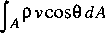 where the angle and the magnitude of the velocity can vary over the area. To compute the mass flux, an estimate must be made of the angle that the local velocity vector makes with the normal to the cross-section surface at all points in the cross-section surface. The computation of the mass flux is simplified if the cross-section surface is defined to be normal to the local velocity vector. Then, = 0 and cos = 1 everywhere in the cross section, so the mass flux becomes
  .
.
To select the cross sections, the flow directions must be known. The problem of needing flow directions before solving the flow equation is only apparent and is similar to the generalization from a uniform velocity in a plane cross section to a nonuniform velocity in a plane section. This generalization forces coefficients to be introduced so that expressions in which the velocity is averaged across the section give the correct flux of momentum or energy. For example, the total flux of momentum across an area in the flow is  . The momentum-flux correction coefficient,
  , is then defined by
 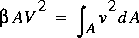 , where V is the cross-sectional average velocity and is a constant. The local velocities appear to be needed before can be defined, but that is not true; only knowledge of the distribution of the velocity in a relative sense is needed. The actual velocities do not need to be known and, in practice, the variation of conveyance across the stream channel is used to provide a surrogate estimate of the velocity distribution.
When the cross sections are curved, the momentum flux also should reflect the directional nature of momentum flux. The momentum per unit volume in the direction of the distance axis becomes v cos  , where is the angle between the direction of the velocity and the direction of the distance axis at the location of the cross section. The defining equation for then becomes
 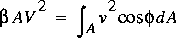 . The effect of the direction on the momentum flux is small. A constant value of = 15° yields an error in momentum flux of less than 4 percent. The effect of curvature on momentum flux is only substantial if the cross section is strongly curved. The same reasoning applied to the integrated hydrostatic pressure on a cross section analyzed in the plan as defined here,
Although exact definition of the flow direction is impossible, reasonable assumptions can be made that provide satisfactory results. Approximate flow directions can be defined by use of a topographic map of the stream and flood plain, at a scale large enough to show sufficient detail. The general direction of flow when the depth of flow is not shallow is the central point of attention. Judgment is required to (1) select the features that are to be included in the definition of the cross-section boundary and which features are to be considered part of the roughness, and (2) determine the general direction of the flow from the pattern of contour lines over a region and not at a point. The goal is to assign the directions of flow that will be followed at each location when the flow is high enough to minimize the effect of local features.
Determination of appropriate flow directions may depend on the water-surface elevations assumed for the stream. An example is a strongly meandering stream with a broad, gently sloping flood plain, as sketched in figure 6. When the flow is within the banks of the main channel, the direction of flow is the same as the direction of the main channel. As the water level increases, water moves into the flood plain, and some water takes a shorter route downstream. At yet higher water levels, the main channel becomes deeply submerged and the direction of flow is affected primarily by the flood-plain topography. The principal difficulty in this example is deciding at what water levels the change in direction results. In some streams, the directional effect of the main channel will always be significant; in others, it will not.
The stream shown in figure 6 is the most general case, and lines showing the direction of flow sketched on a topographic map, called flow lines, would intersect. Lines that intersect would be those applicable to the flow at various water levels. Cross sections drawn locally perpendicular to these flow lines (orthogonal to the flow lines) would then have curvature in the horizontal plane that changes with the water level; that is, the cross sections would change orientation or twist as the water level increases. Hence, they become 3-D cross sections instead of the 2-D cross sections currently used in available modeling systems. Measuring such sections in the field would be difficult, and a detailed topographic map of the stream and flood plain would be needed to complete the cross sections.
Describing these cross sections so that the cross-sectional characteristics could be computed would be difficult. The flow lines between sections also must be described in some way to specify the geometry. With these practical difficulties and the theoretical difficulties of major shifts in direction and the corresponding interaction between the flow in the main channel and the flood plain, representing a strongly meandering stream with a combined cross section for the main channel and flood plain seems unwise and impractical. The interaction between the main channel and flood plain in the computation of conveyance cannot be identified in a combined cross section. Better and perhaps simpler is to isolate this interaction and approximate this interaction explicitly by creating a system of two or more channels, each with the cross sections orthogonal to the corresponding flow lines, and by providing explicit interchange of flows between channels through use of flow relations that depend on differences in water-surface elevations between channels. These relations may be difficult to select, but the difficulty is explicit instead of implicit; this is a conceptual improvement because the uncertainties are more explicitly recognized and, thus, more caution can be exercised in presenting and using the results.
In figure 6, one or two channels would represent flood-plain flows and one would represent the main-channel flow. Direction of flow in each individual channel would be virtually independent of changes in water level. Thus, sketching of the flow lines becomes easier and the cross sections can be tailored to the needs of each channel with the cross-section spacing reflecting that channel only. The flow lines for a multiple-channel model would not intersect and flow-line intersection might be a reasonable criterion for deciding if a multiple-channel model is needed. If flow lines cannot be sketched that are, to a large degree, independent of changes in water level, then a multiple-channel model should be considered. Each channel would have a distinct distance axis and cross-section spacing and orientation. Computational difficulties may result for zero or near zero flow in the flood-plain channel for multiple-channel models during low flows. These difficulties are addressed later.
Interchange of water and momentum between interacting channels would be at interaction points placed at periodic intervals along the channels. These would approximate the continuous interchange in the stream system by a series of discrete weirs. By careful selection of the interaction points and definition of the flows, the theoretical basis for the results can be improved by making the interchange of momentum explicit. This multiple-channel model, although not much different in complexity than the single-channel model with variable-curvature twisted cross sections, nonetheless represents the strongly meandering stream more accurately with 1-D approximations than a single-channel model does. The approximation of the system can be improved only by use of a 2-D model at a considerable increase in time and effort.
Given the restriction that the flow lines should be independent of water-surface elevation, the cross sections in curvilinear 1-D flow can be defined by means of the following steps:
- Sketch several flow lines on a topographic map showing the direction that water would flow if it were sufficiently deep to inundate minor topographic features. At least five flow lines are necessary: one along the thalweg of the channel, one near each bank of the main channel, and two showing the extent of the flood plain. Intermediate flow lines may be needed to reflect local variations within the main channel or on the flood plain.
- Sketch the cross sections such that they are approximately orthogonal to the flow lines. If = 15° everywhere, then the error in the flow rate estimate is less than 4 percent, and if = 30°, the error is about 15 percent. (Moreover, in estimating differences between the mass inflow and the mass outflow, there is some opportunity for compensation of errors in defining the cross-section locations.) The cross sections will be curved surfaces, not planar. Ideally, the cross section measured in the field should follow this curved path as closely as is practical. The curved cross sections sketched on the topographic map may be replaced by plane cross sections if the plane sections do not intersect within the flow field and if the angles of intersection with the flow lines are approximately perpendicular.
A hypothetical example of this process is shown in figure 7. The main-channel boundaries and the flood-plain limits are considered to be approximate flow lines (although rigorously this is not true). The edge of the water in the channel is a flow line, but this line depends on the variation of water-surface elevation with distance that is unknown. Thus, the flow lines must be sketched in a general sense, with the assumption that they will apply approximately to flow at a wide range of water-surface elevations. (That is why the lines showing the direction of flow are referred to as "flow lines" instead of "streamlines." To call them streamlines would make the analysis seem more exact than is really possible.) For any real flow, some of the sketched flow lines will likely be only partially under water; that is, one or more of the approximate flow lines will intermittently be included in the wetted part of the channel as viewed on the horizontal plane. This should not be a problem if the direction of the flow line is within an acceptable angle of the direction of flow when the flow line, as sketched, is inundated. What is acceptable depends on the desired accuracy of the analysis. Clearly, a difference of direction of 45° is suspect, but a deviation of 30° should not be of concern.
4.2.3 Selection of Distance Axis
The flow lines and intersecting cross sections define the channel geometry in three dimensions. Transformation of this geometry to one dimension requires definition of a curvilinear distance axis. The thalweg of the channel--that is, the locus of the minimum elevation points in the main channel--is a convenient choice for the distance axis. For some stream reaches, this definition applies to more than one part of the channel, but a reasonable choice can be made for those cases where the cross sections have multiple and equal points of minimum elevation. In the following discussion, the distance axis is assumed to be the thalweg of the channel or near to it.
Cross sections at any location along the distance axis must be defined such that they will not intersect and will approximately meet the requirements of a simple mass-flux computation. To apply the conservation of mass principle to the water in the stream, the volume of water between any two cross sections along the stream must be defined. Let x denote the distance variable, y(x) denote the height [NOTE1] of the water surface above the minimum point in the cross section at the location given by x, and A[x,y(x)] denote the area of the cross section at the location along the distance axis given by x. As x varies, the curvature of the cross section will vary. In the 1-D equations, all cross sections must be referenced by location along the distance axis; information regarding any other distances between cross sections is unavailable. The following is a development of a systematic method for summarizing the effects of this distance variation on the 1-D equations.
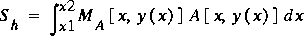
The apparently natural formula for computing the volume of water, S, in the channel between a section at x1 and one at x2 is
(1)
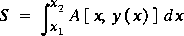 ,
,
where y(x) is assumed to be a known function. Equation 1 is incorrect when applied to curvilinear channels. To obtain the correct volume by integrating in one dimension only, the integrand must represent a volume per unit length. The unit length is defined by the variable of integration. If the cross sections are plane and parallel, then Ax is a valid volume increment where x is the distance between cross sections at x1 and x2. For curvilinear channels, however, the cross sections are neither plane nor parallel. Thus, multiplication of a small distance increment by an area yields a volume increment, but not the correct volume increment. The volume increment would be correct if two cross sections x apart at the x-axis would be the same distance apart, measured parallel to the x-axis, at all other points in the cross section. This is true if the cross sections are plane or curved. If the cross sections are plane surfaces and the x-axis follows the path traced by the centroid of the cross sections, then it also is valid though the distance between cross sections varies with position in the section. These are special cases, although the latter is important because equation 1 is correct in this case if the cross sections are plane and the distance axis is the same as the path of the centroid of the areas. This can only result for varying heights of water, y(x), if the cross sections are symmetrical about a vertical line and the distance axis coincides with the trace made by the line of symmetry on the horizontal plane.
In general, stream cross sections are not symmetrical, especially in bends, and the path formed by their centroids shifts with the water-surface profile. Thus, an approach is needed to represent the channel volume in a set of 1-D governing equations. Using DeLong's (1989) approach, a weight coefficient is introduced so that the product of the weight coefficient and the area will yield a valid volume per unit length along the distance axis. This weight coefficient will vary with distance, water height, and the choice of the distance axis.
The weight coefficient, MA, that will result in a valid volume per unit length when multiplied with the cross-sectional area is defined as
(2)
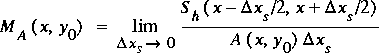 ,
,
where xS is a small increment along the distance axis of the channel, y0 is a constant water-surface height, x is the cross-section location, A(x, y0) is the flow cross-sectional area at location x for water-surface height y0, and Sh(x1,x2) is the correct volume of water between cross sections at locations x1 and x2.
The computation of MA can be done at enough points at the cross-section locations in a 1-D model so that the coefficient is defined as accurately as the area or top width. Because the weight coefficient is defined at any point, the volume integral can be written as
(3)
 .
.
The evaluation of the exact volume of the slice needed in the definition is presented in the development of the actual means of computing the cross-section characteristics.
The conservation of momentum principle requires the evaluation of the change in momentum content of the water in the stream. This also requires an integration along the distance axis and over the flow field (cross section). This integration is complicated because the flow is not uniformly distributed along the cross section, the momentum content is a vector quantity, and the direction for the vector is taken as that given by the distance axis. Thus, to be rigorous, the analysis should include the cosine of the angle between the direction of the distance axis and the assumed direction of the velocity at each point in the volume of water for which momentum content is estimated. However, the results of the experiments of Miller and Chaudhry (1989), mentioned previously in this report, indicate this refinement is not needed. Thus, the momentum content is considered in FEQ as if the angle were zero everywhere.
The weight coefficient, MQ, that will result in a valid momentum content per unit length when multiplied with the total flow rate through the cross section is defined as
(4)
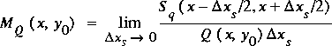 ,
,
where Q(x,y0) is the total flow rate through the cross section at location x for water-surface height y0, and Sq(x1,x2) is the correct momentum content of the flow between cross sections at locations x1 and x2. The momentum-content integral can be written as
(5)
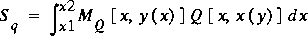 .
.
The means for defining the flow per unit width is described in section 5.
These two weights, MA and MQ, represent the effect of curvature of the channel on the application of the 1-D principles of conservation of mass and momentum, respectively, to open-channel flow. The methods applied to determine the exact volume by means of multidimensional integration are described later, after descriptions of how to develop other cross-section characteristics that depend only on the cross section and not on its orientation or the location of the distance axis.
- 4.2.1 Channel Geometry Requirements For One-Dimensional Analysis
-
- 4.2.2 Orientation of Cross Sections
-
- 4.2.3 Selection of Distance Axis
-
[Next Section]
[Previous Section]
[Table of Contents]