

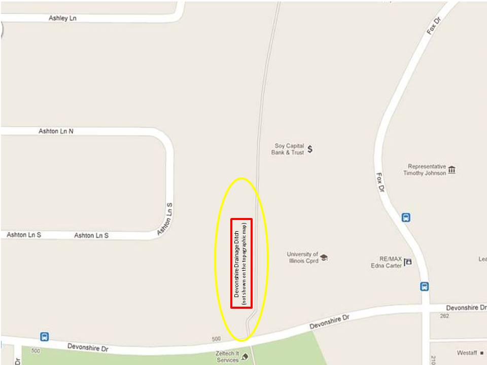
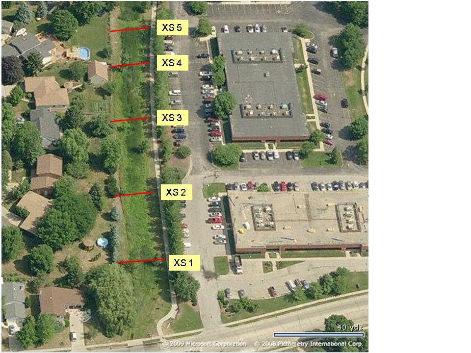
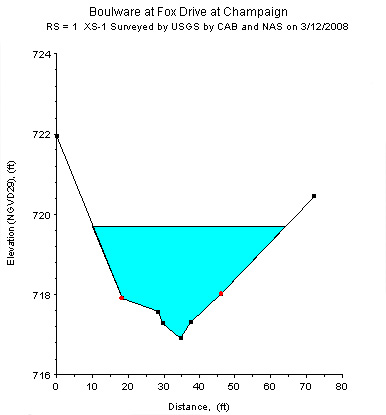
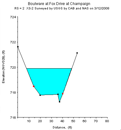

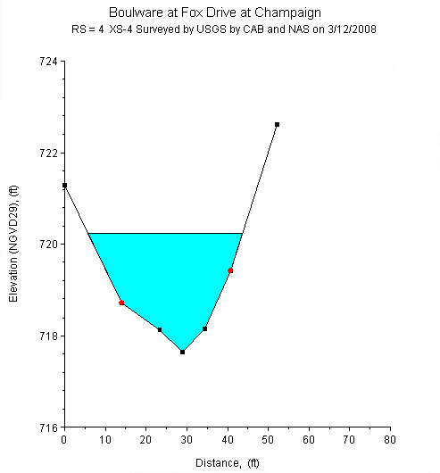
Study Reach.--The channel reach is a drainage ditch in an urban setting, as shown in quadrangle map on the top left. The study reach is approximately 800 ft long and is located upstream of the intersection with Devonshire Drive Road. Five surveyed cross sections (surveyed by the USGS-ILWSC in March 2008) are available for describing the geometry of the study reach. Cattails fill the channel seasonally. The channel alignment is relatively straight and cross sections were reworked to a trapezoidal shape. The channel alignment, approximate variations on channel width and bank conditions, and locations of the cross section are shown in the aerial photograph on the top right. Four cross sections are selected to illustrate the cross sectional and longitudinal variations of the geometry. It can be seen from the plots above that the cross sectional shape is essentially trapezoidal but erosion and deposition patterns are developing in the bed area.
Gage Location.-- Lat 40°05’23”, long 88°15’08”, in NW1/4NE1/4SW1/4 sec.24, T.19N., R.08E., Champaign County, Hydrologic Unit 05120112, located in the channel upstream of Devonshire Drive Road bridge. The USGS streamgage station number is 03343170.
To reach gage.--From US Highway 150 (Springfield Ave.) in Champaign, drive South approximately 1.5 miles on US Highway 45 (S. Neil St), then West on Devonshire Dr for approximately 0.3 miles. The gaging station is a series of staff gages located in the channel along a recreation trail north of the Devonshire Dr. bridge.
Drainage Area.-- 0.65 sq mi.
Gage Datum and Elevations of Reference Points.-- Datum of the gage is 700.00 ft. NAVD88.
Stage, Discharge Measurement, and Computed n-Values.--Water-surface elevations were measured by reading the three staff gages located in the channel before, during, and after each discharge measurement. Discharge measurements were made using both an Acoustic Doppler Velocimeter or an Acoustic Doppler Current Profiler (ADCP). When possible, multiple discharge measurements were made during an event that covered the rising and receding limbs for evaluating n-values over a range in stage. The computed n-values are listed in the following table. Whenever possible, the computed n-values are associated with a photograph taken at the time of the measurement. The photographs are arranged from low to high discharge in order to illustrate the contributing factors of n-values at a particular discharge.
| Date of Observation | Discharge (ft3/s) | Average Cross Section Area (ft2) | Hydraulic Radius (ft) | Mean Velocity (ft/s) | Slope (ft/ft) | Coefficient of Roughness n |
|---|---|---|---|---|---|---|
| 5/19/2008 | 0.5 | 9.6 | 0.41 | 0.05 | 0.001693 | 0.726 |
| 5/19/2008 | 0.5 | 7.2 | 0.36 | 0.07 | 0.001440 | 0.402 |
| 5/16/2008 | 0.6 | 6.7 | 0.35 | 0.09 | 0.001298 | 0.314 |
| 5/19/2008 | 0.6 | 12.3 | 0.48 | 0.05 | 0.001930 | 0.792 |
| 5/16/2008 | 0.7 | 6.8 | 0.35 | 0.10 | 0.001300 | 0.262 |
| 5/16/2008 | 0.8 | 6.5 | 0.34 | 0.13 | 0.001294 | 0.205 |
| 5/16/2008 | 0.9 | 6.5 | 0.34 | 0.14 | 0.001298 | 0.193 |
| 4/25/2010 | 3.0 | 17.5 | 0.63 | 0.17 | 0.001619 | 0.261 |
| 5/19/2008 | 4.0 | 21.1 | 0.72 | 0.19 | 0.001837 | 0.269 |
| 5/19/2008 | 4.2 | 20.7 | 0.71 | 0.20 | 0.001738 | 0.246 |
| 5/19/2008 | 4.4 | 21.0 | 0.72 | 0.21 | 0.001783 | 0.241 |
| 9/2/2010 | 7.8 | 38.6 | 1.12 | 0.20 | 0.002408 | 0.382 |
| 9/2/2010 | 9.0 | 36.9 | 1.09 | 0.24 | 0.002224 | 0.301 |
| 6/3/2008 | 19.4 | 59.0 | 1.45 | 0.34 | 0.000748 | 0.159 |
| 6/3/2008 | 20.6 | 62.4 | 1.50 | 0.34 | 0.000876 | 0.175 |
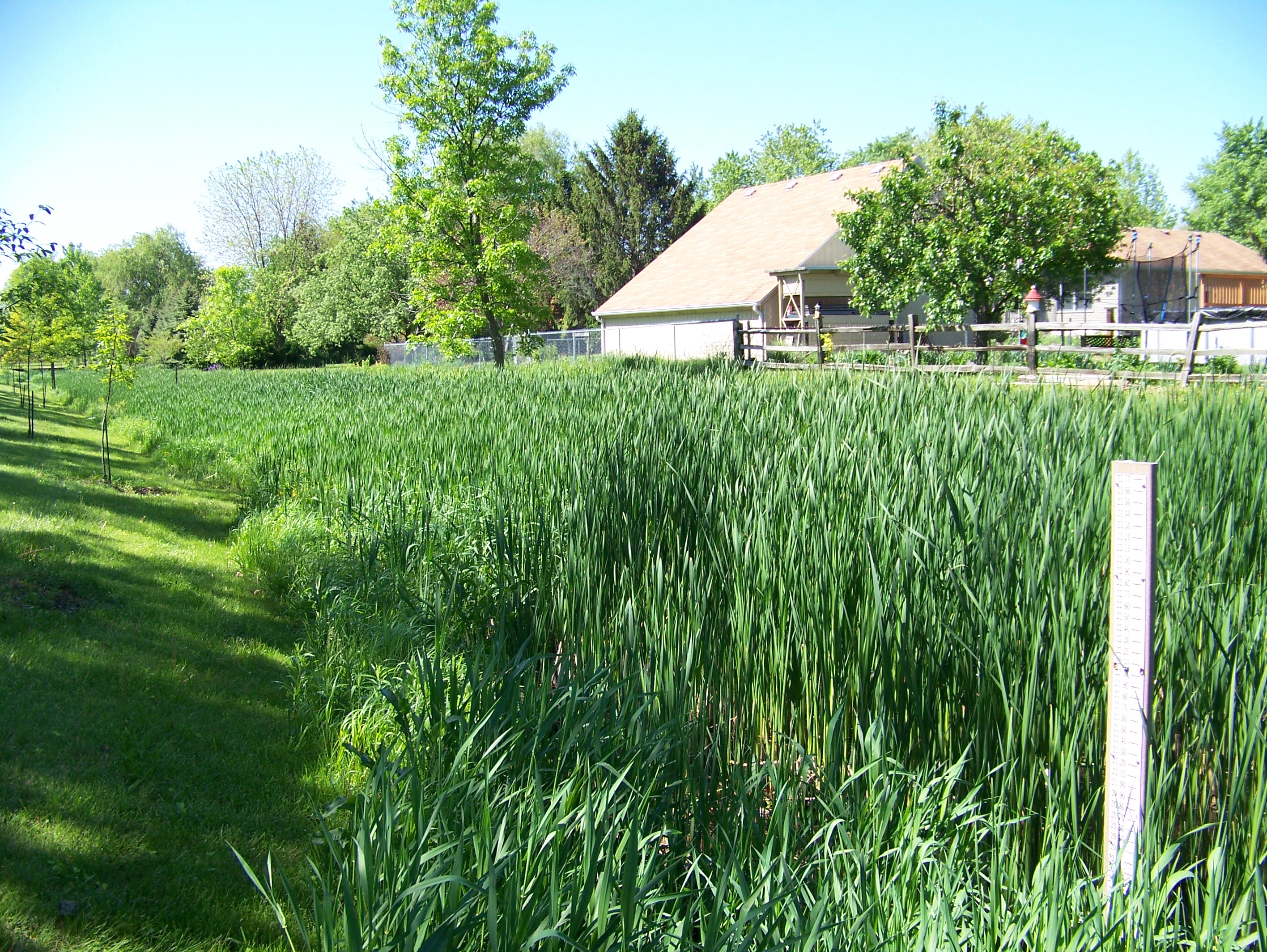
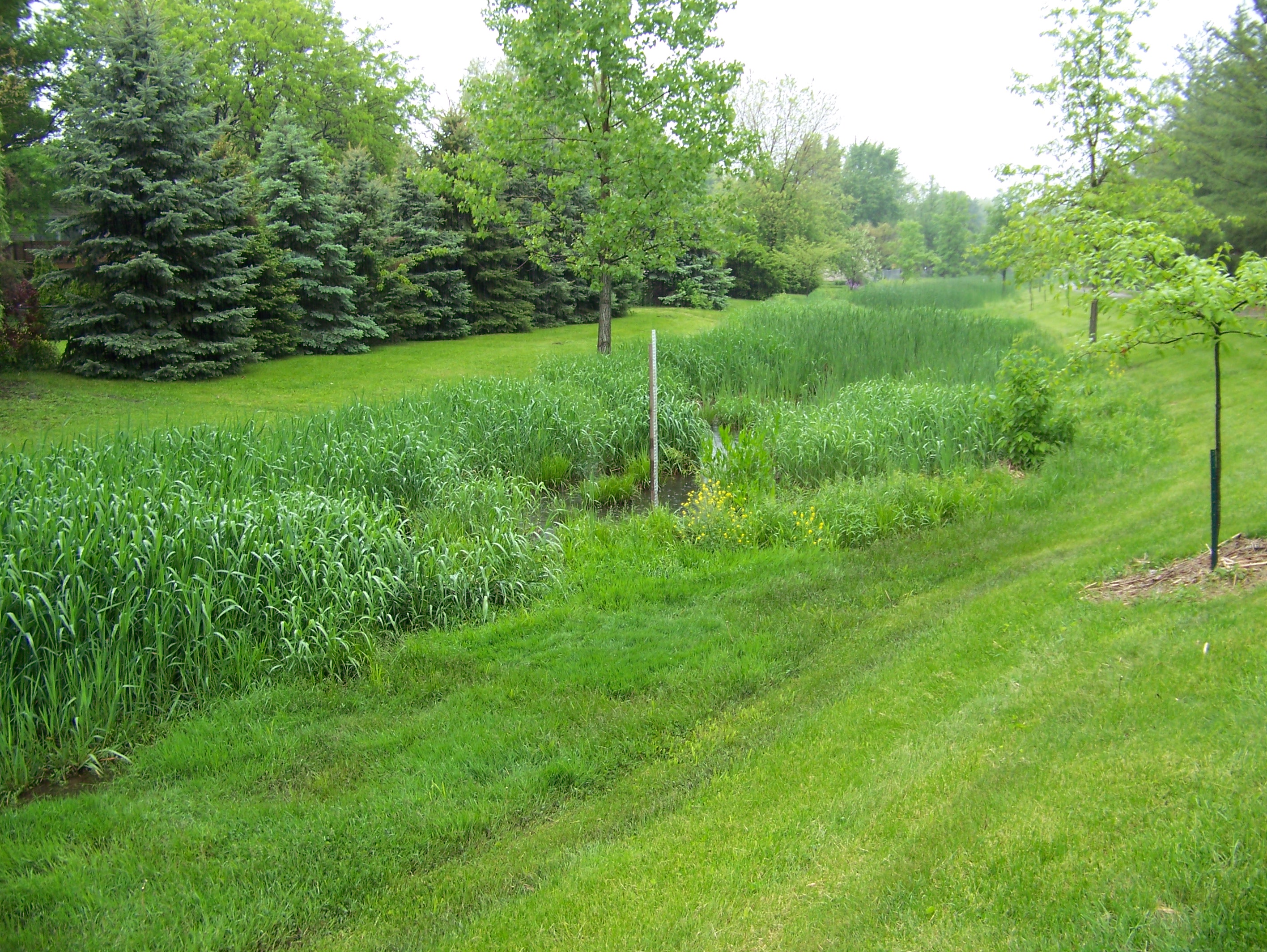
Description of the Channel. .--The alignment of the study reach is straight. Its channel has been reworked to form a trapezoidal shape and that shape remained at the time of survey in March, 2008, except for the development of local erosion or deposition. The bottom width of the channel is approximately 26 ft. During growing seasons most of the streambed is covered with cattails except for the most downstream section, which is covered by weeds. The bank has a mild slope (~15ş) and is covered with mowed grass with evenly spaced young trees (~5 inches in diameter). The top width of the channel is approximately 50 ft.
Floods.--Maximum discharge, 20.6 ft3/s, from direct measurement on June 3rd, 2008. The gage height was 20.23 ft at the upstream staff gage and 19.75 ft at the downstream staff gage.

![]() U.S. Department of the Interior |
U.S. Geological Survey
U.S. Department of the Interior |
U.S. Geological Survey
URL: http://il.water.usgs.gov/proj/nvalues/db/sites/03343170.shtml[an error occurred while processing this directive]?
Page Contact Information: David Soong
Page Last Modified: February 4, 2013
