Determination of Roughness Coefficients for Streams in West-Central Florida
02295420 Payne Creek near Bowling Green, Fla.
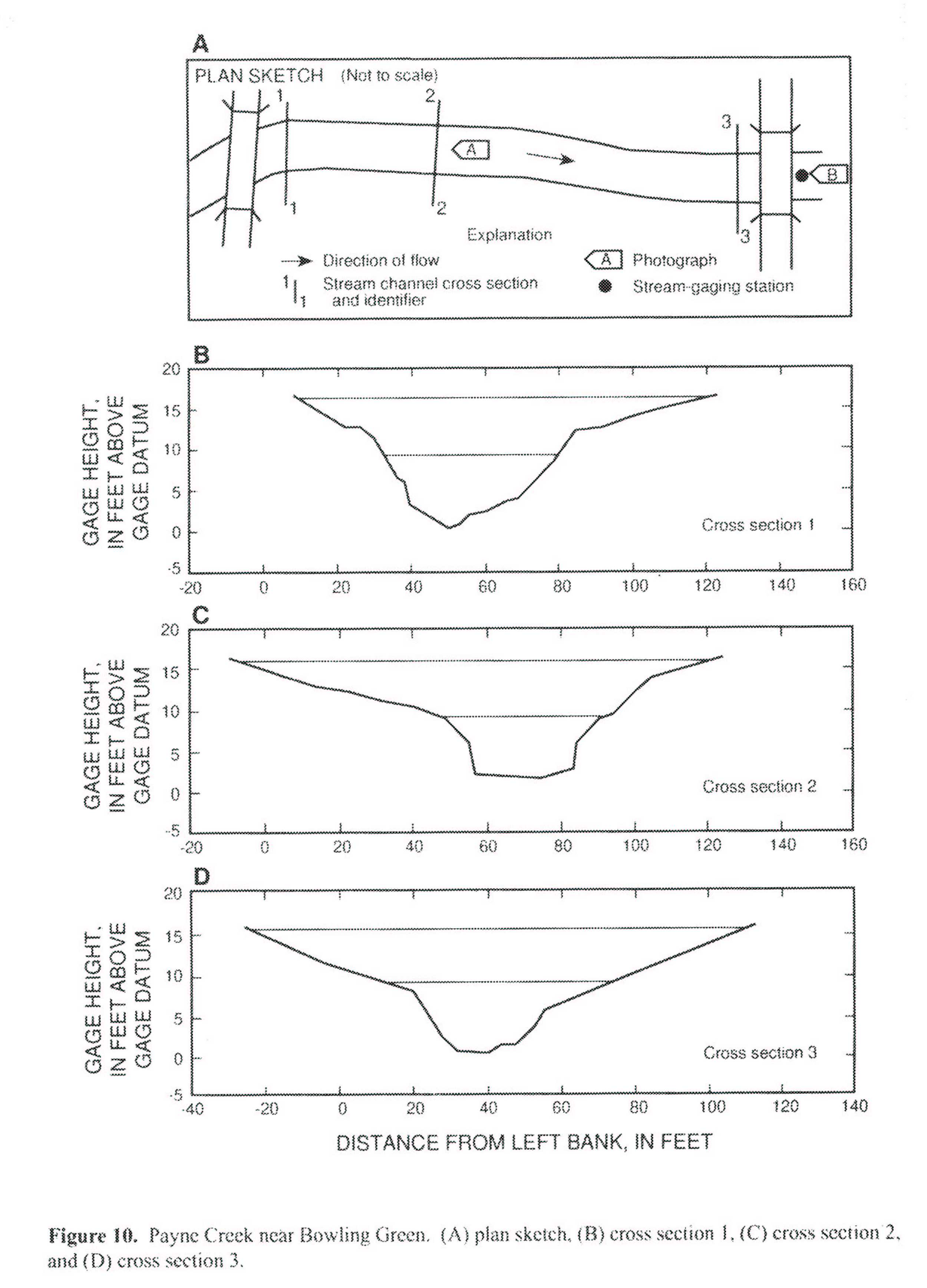
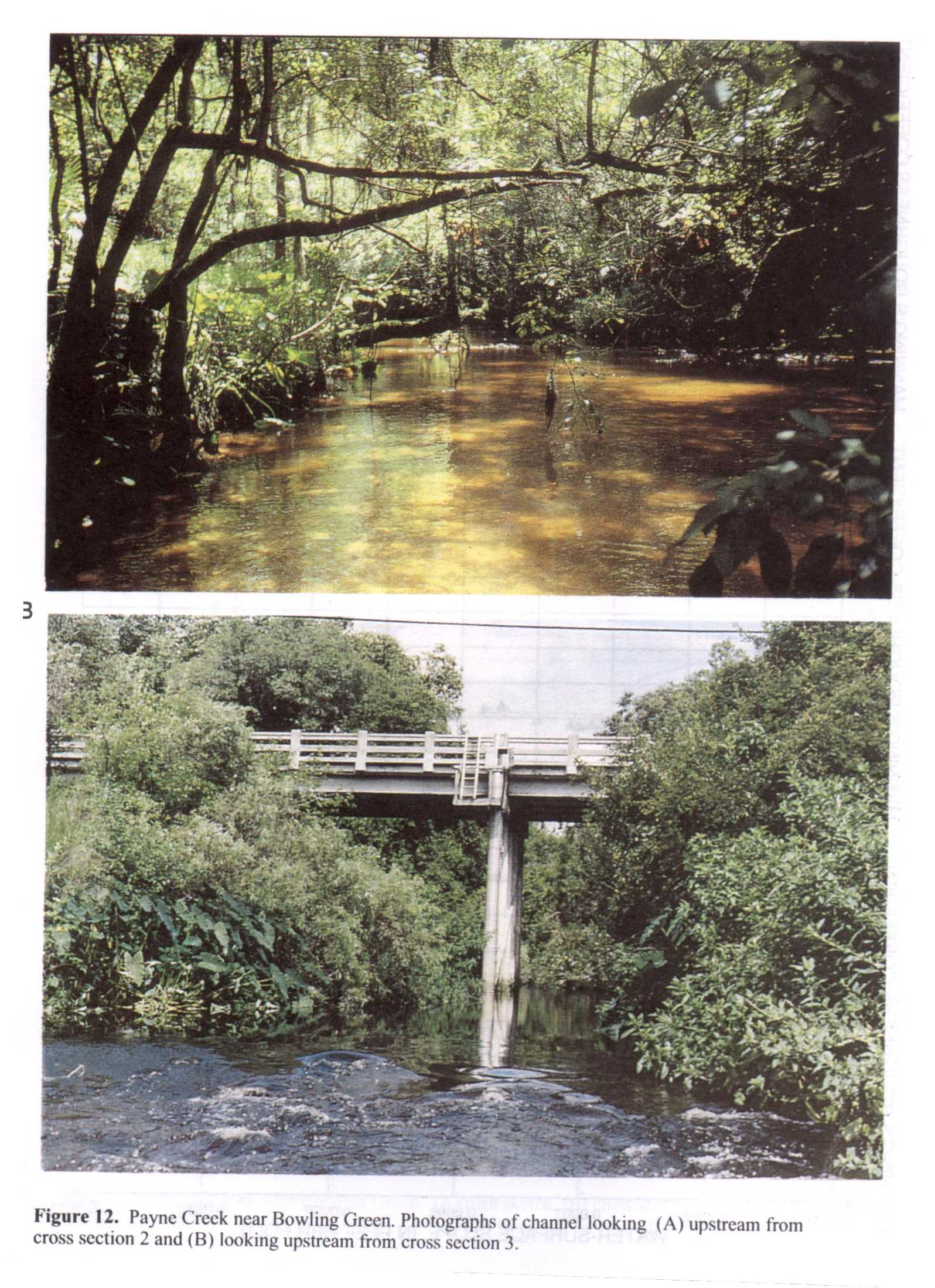 Location
.-- Lat 27°37'14", long 81°49'33", near Bowling Green, Florida.
Description of channel.--
d50 = 0 mm.
d84 = 0 mm.
| Date of observation | Average depth (ft) | Average surface width (ft) | Discharge (ft3/s) | Average cross section area (ft2) | Hydraulic radius (ft) | Mean velocity (ft/s) | Slope | Coefficient of roughness n |
|---|
| Sept. 10, 1988 |
--- |
--- |
1500.0 |
899.0 |
6.60 |
1.680 |
0.001030 |
0.104 |
| Aug. 15, 1992 |
--- |
--- |
915.0 |
550.0 |
5.60 |
1.680 |
0.000810 |
0.081 |
| Aug. 12, 1992 |
--- |
--- |
852.0 |
497.0 |
5.55 |
1.730 |
0.000700 |
0.071 |
| Aug. 11, 1992 |
--- |
--- |
728.0 |
712.0 |
5.35 |
1.780 |
0.000670 |
0.064 |
| Aug. 09, 1992 |
--- |
--- |
674.0 |
380.0 |
5.23 |
1.790 |
0.000710 |
0.065 |
| June 30, 1992 |
--- |
--- |
607.0 |
336.0 |
4.99 |
1.820 |
0.000640 |
0.058 |
| Sept. 05, 1992 |
--- |
--- |
539.0 |
298.0 |
4.77 |
1.820 |
0.000640 |
0.056 |
| June 29, 1992 |
--- |
--- |
524.0 |
289.0 |
4.72 |
1.820 |
0.000630 |
0.055 |
| Sept. 15, 1992 |
--- |
--- |
491.0 |
272.0 |
4.63 |
1.810 |
0.000660 |
0.056 |
| June 26, 1992 |
--- |
--- |
460.0 |
256.0 |
4.56 |
1.800 |
0.000650 |
0.056 |
02295637 Peace River at Zolfo Springs, Fla.
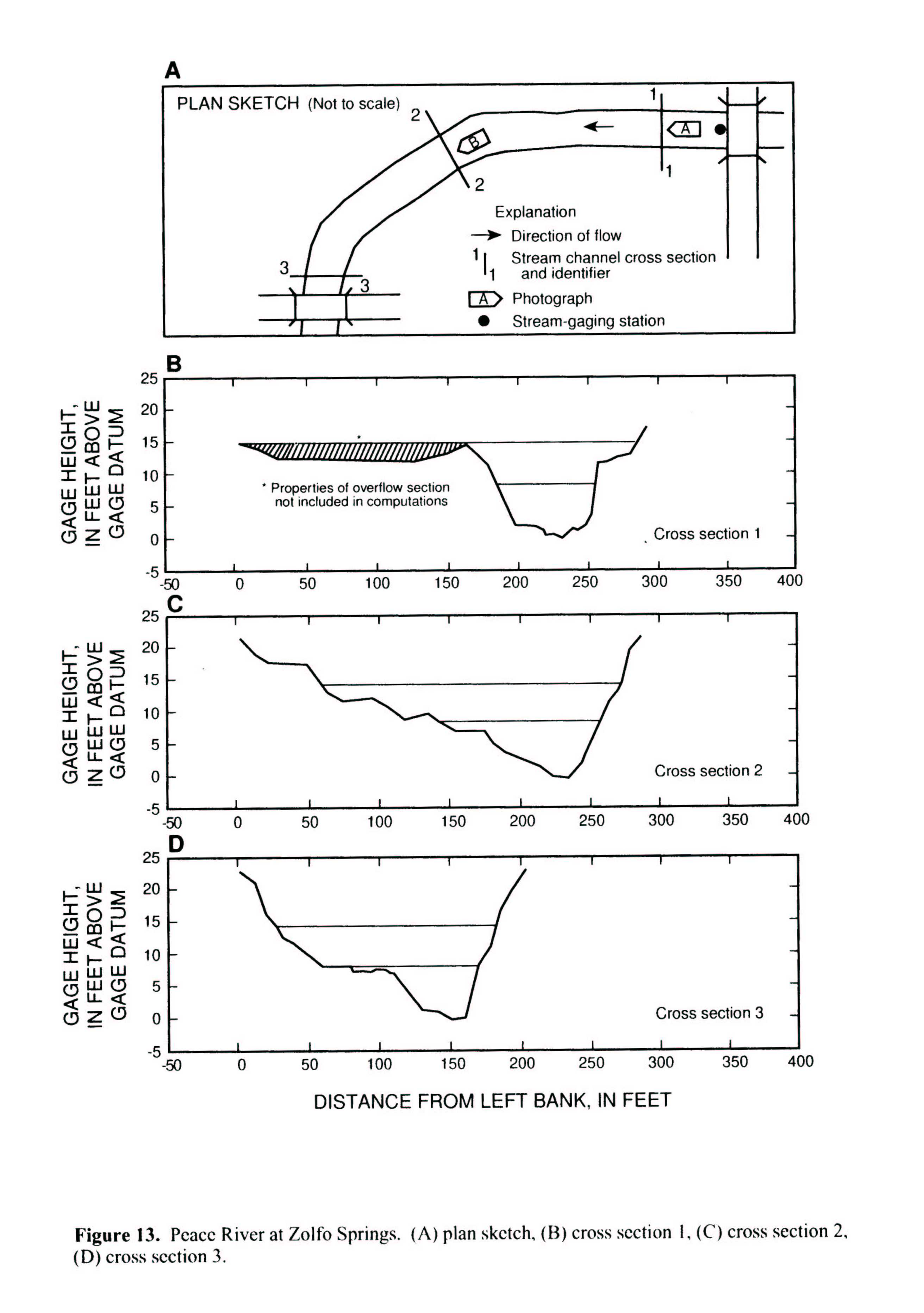
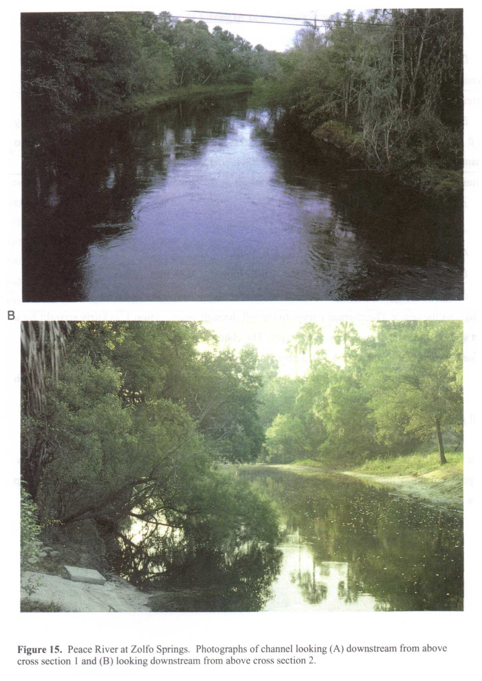 Location
.-- Lat 27°30'15", long 81°48'04", near Zolfo Springs, Florida.
Description of channel.--
d50 = 0 mm.
d84 = 2 mm.
| Date of observation | Average depth (ft) | Average surface width (ft) | Discharge (ft3/s) | Average cross section area (ft2) | Hydraulic radius (ft) | Mean velocity (ft/s) | Slope | Coefficient of roughness n |
|---|
| Aug. 12, 1992 |
--- |
--- |
3010.0 |
1310.0 |
7.12 |
2.390 |
0.000170 |
0.032 |
| Sept. 05, 1992 |
--- |
--- |
2300.0 |
1100.0 |
6.26 |
2.170 |
0.000160 |
0.031 |
| Aug. 31, 1992 |
--- |
--- |
1860.0 |
947.0 |
5.84 |
2.020 |
0.000140 |
0.029 |
| June 30, 1992 |
--- |
--- |
1810.0 |
925.0 |
5.77 |
2.010 |
0.000130 |
0.029 |
| Oct. 05, 1992 |
--- |
--- |
1760.0 |
904.0 |
5.71 |
2.000 |
0.000130 |
0.029 |
| Sept. 17, 1992 |
--- |
--- |
1120.0 |
644.0 |
5.48 |
1.770 |
0.000100 |
0.029 |
| Sept. 30, 1992 |
--- |
--- |
865.0 |
523.0 |
4.94 |
1.680 |
0.000080 |
0.026 |
| Oct. 13, 1992 |
--- |
--- |
837.0 |
504.0 |
4.88 |
1.680 |
0.000090 |
0.029 |
| Feb. 04, 1993 |
--- |
--- |
790.0 |
477.0 |
4.73 |
1.680 |
0.000110 |
0.030 |
02297155 Horse Creek near Myakka Head, Fla.
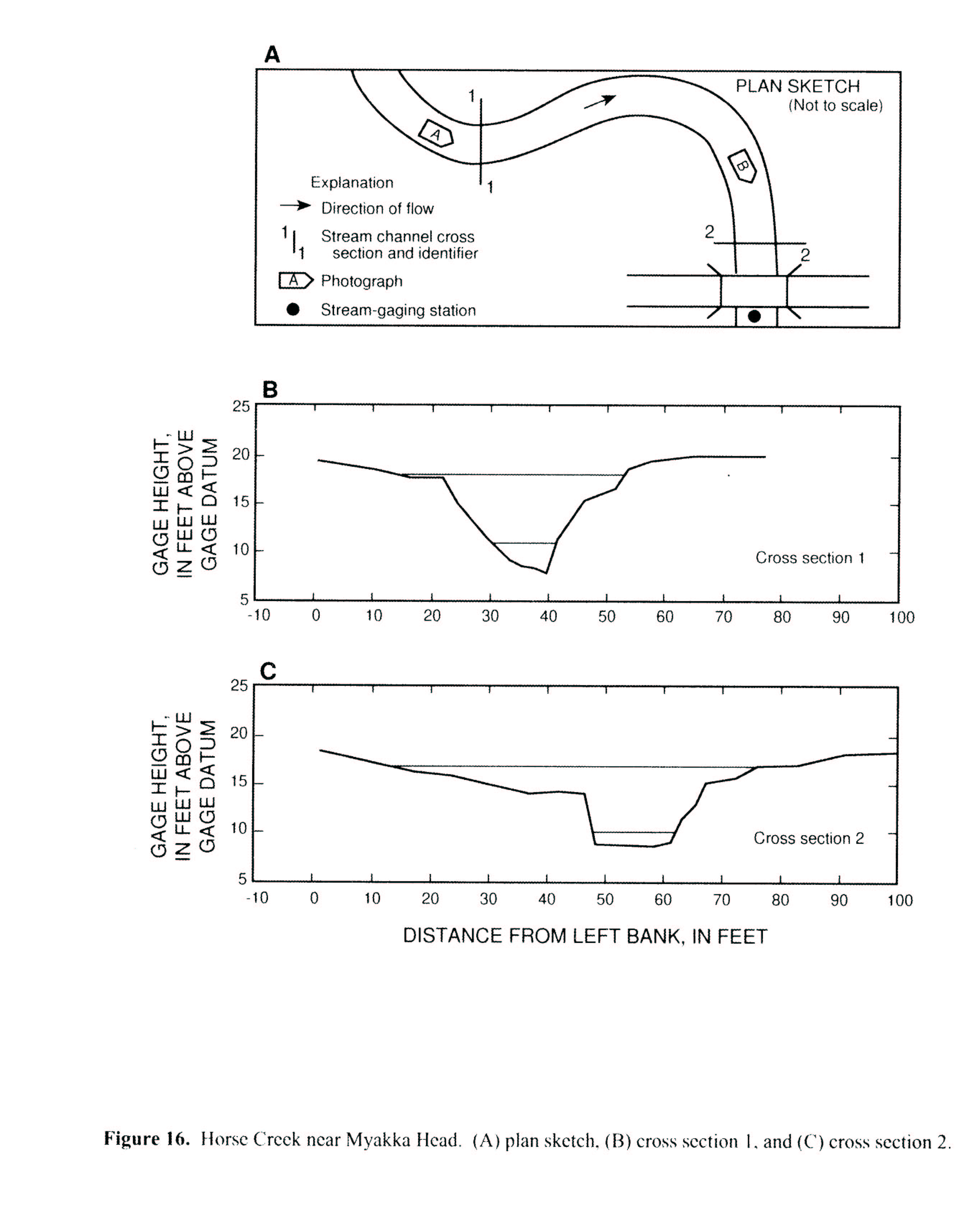
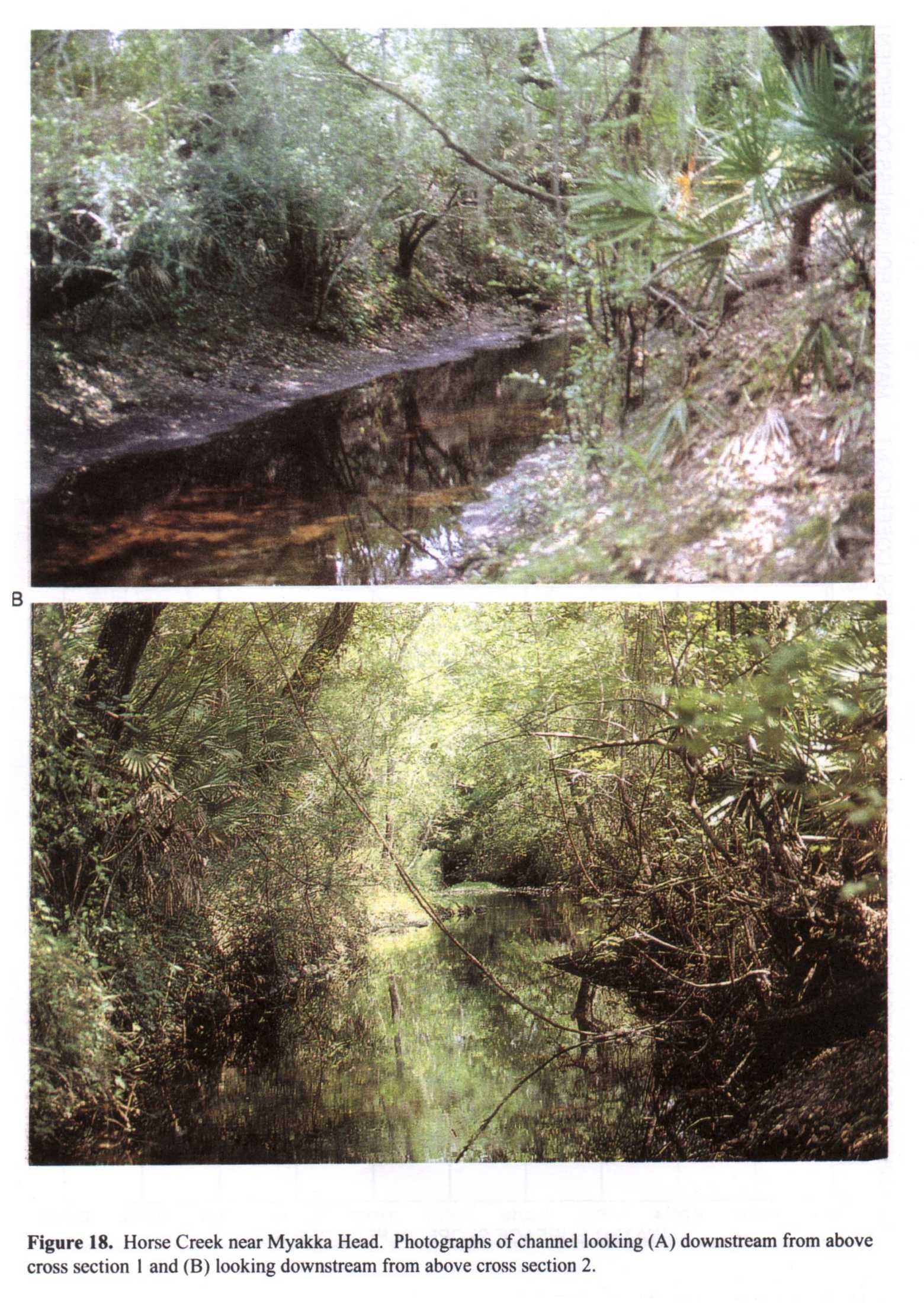 Location
.-- Lat 27°29'13", long 82°01'25", near Myakka Head, Florida.
Description of channel.--
d50 = 0 mm.
d84 = 0 mm.
| Date of observation | Average depth (ft) | Average surface width (ft) | Discharge (ft3/s) | Average cross section area (ft2) | Hydraulic radius (ft) | Mean velocity (ft/s) | Slope | Coefficient of roughness n |
|---|
| Sept. 02, 1994 |
--- |
--- |
529.0 |
232.0 |
3.43 |
2.400 |
0.001600 |
0.060 |
| Apr. 01, 1993 |
--- |
--- |
495.0 |
208.0 |
3.36 |
2.500 |
0.001470 |
0.054 |
| Aug. 11, 1992 |
--- |
--- |
488.0 |
203.0 |
3.35 |
2.500 |
0.001600 |
0.056 |
| Mar. 13, 1993 |
--- |
--- |
211.0 |
73.3 |
3.00 |
2.890 |
0.001630 |
0.044 |
| Sept. 17, 1992 |
--- |
--- |
69.0 |
31.1 |
1.84 |
2.240 |
0.001500 |
0.039 |
| Oct. 13, 1992 |
--- |
--- |
37.0 |
22.9 |
1.49 |
1.600 |
0.002270 |
0.058 |
| Feb. 04, 1993 |
--- |
--- |
22.0 |
18.3 |
1.28 |
1.200 |
0.002410 |
0.071 |
02299737 South Creek near Vamo, Fla.
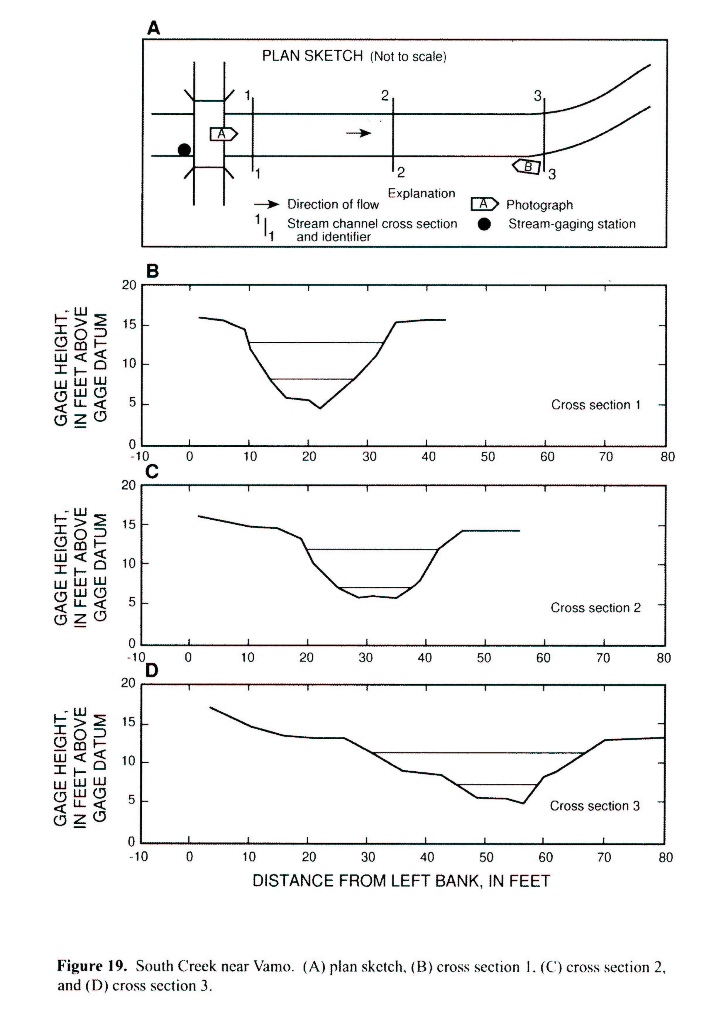
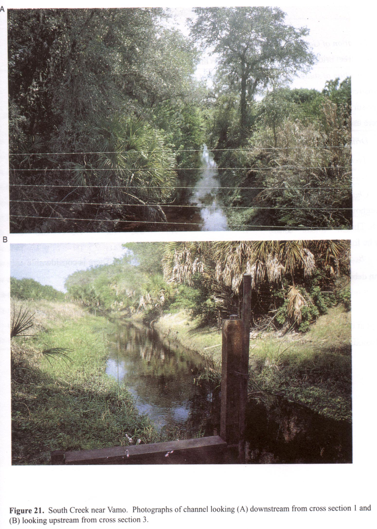 Location
.-- Lat 27°11'46", long 82°27'46", near Varno, Florida.
Description of channel.--
d50 = 0 mm.
d84 = 0 mm.
| Date of observation | Average depth (ft) | Average surface width (ft) | Discharge (ft3/s) | Average cross section area (ft2) | Hydraulic radius (ft) | Mean velocity (ft/s) | Slope | Coefficient of roughness n |
|---|
| Apr. 02, 1993 |
--- |
--- |
166.0 |
114.0 |
3.58 |
1.470 |
0.000380 |
0.047 |
| Apr. 05, 1993 |
--- |
--- |
130.0 |
93.1 |
3.18 |
1.410 |
0.000360 |
0.043 |
| Mar. 13, 1993 |
--- |
--- |
94.0 |
72.2 |
2.74 |
1.300 |
0.000330 |
0.040 |
| Jan. 16, 1993 |
--- |
--- |
59.0 |
50.3 |
2.26 |
1.240 |
0.000410 |
0.043 |
| Oct. 05, 1992 |
--- |
--- |
55.0 |
48.6 |
2.23 |
1.130 |
0.000380 |
0.043 |
| Jan. 26, 1993 |
--- |
--- |
50.0 |
46.0 |
2.18 |
1.090 |
0.000410 |
0.045 |
| Feb. 27, 1993 |
--- |
--- |
20.0 |
29.7 |
1.72 |
0.660 |
0.000360 |
0.059 |
| Oct. 14, 1992 |
--- |
--- |
13.0 |
26.4 |
1.59 |
0.500 |
0.000520 |
0.090 |
02299861 Walker Creek near Sarasota, Fla.
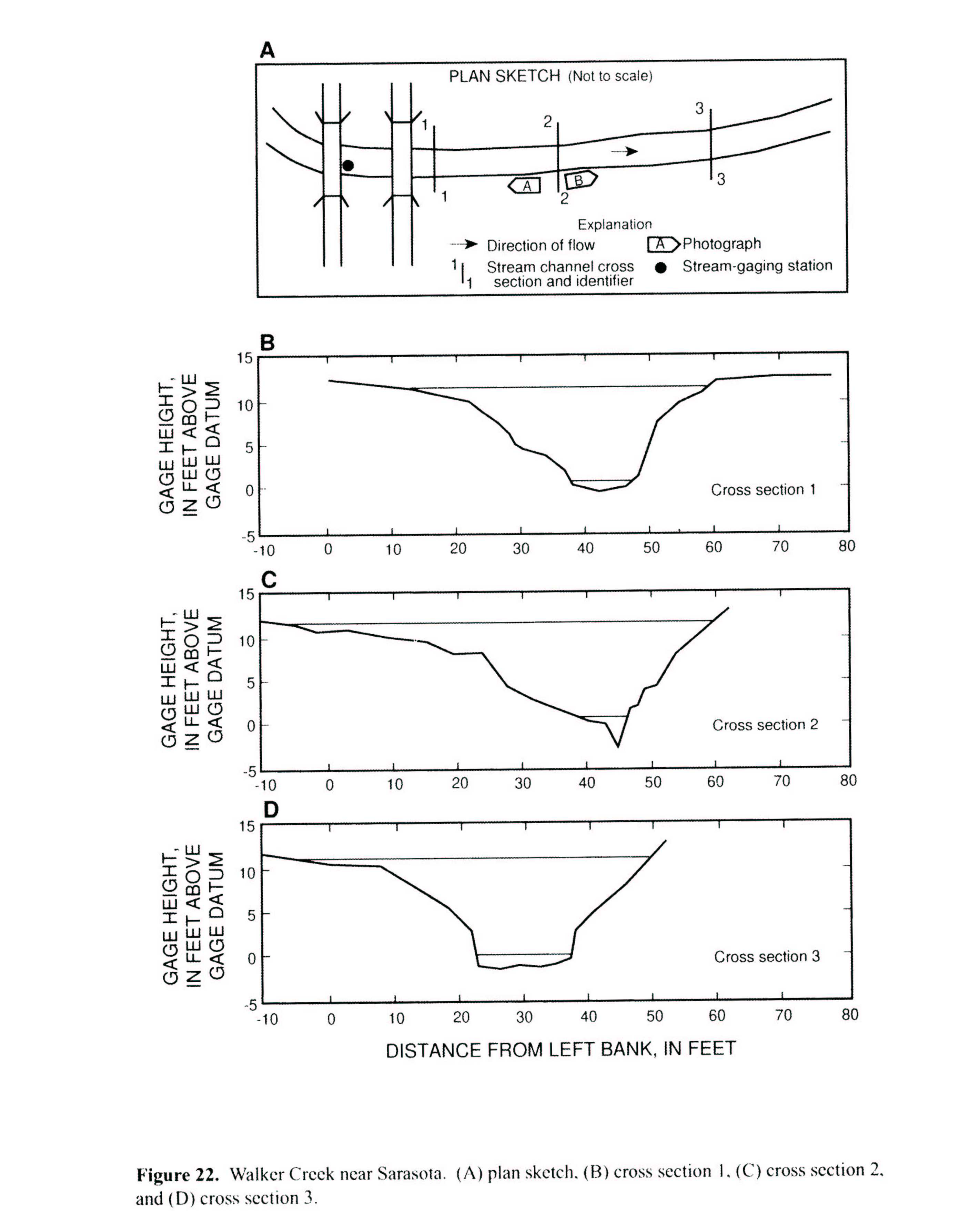
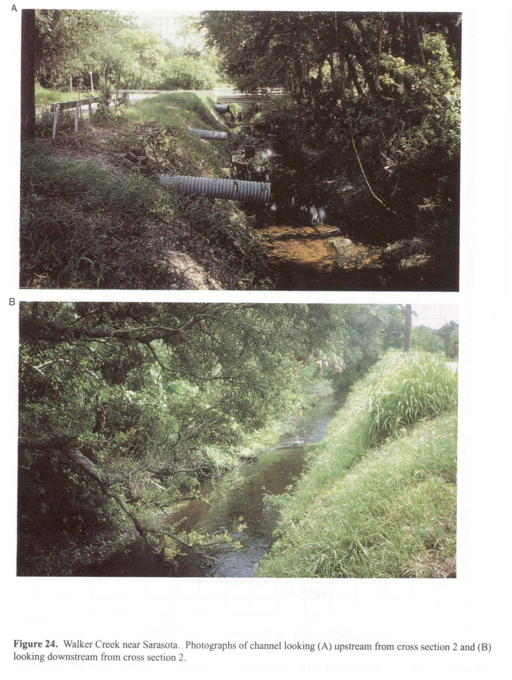 Location
.-- Lat 27°22'03", long 82°32'40", near Sarasota, Florida.
Description of channel.--
d50 = 0 mm.
d84 = 1 mm.
| Date of observation | Average depth (ft) | Average surface width (ft) | Discharge (ft3/s) | Average cross section area (ft2) | Hydraulic radius (ft) | Mean velocity (ft/s) | Slope | Coefficient of roughness n |
|---|
| June 25, 1992 |
--- |
--- |
971.0 |
316.0 |
4.49 |
3.090 |
0.000950 |
0.042 |
| July 23, 1992 |
--- |
--- |
438.0 |
166.0 |
4.14 |
2.570 |
0.000930 |
0.045 |
| Aug. 07, 1992 |
--- |
--- |
398.0 |
157.0 |
4.40 |
2.290 |
0.000800 |
0.044 |
| Apr. 01, 1993 |
--- |
--- |
312.0 |
131.0 |
3.79 |
2.400 |
0.000970 |
0.048 |
| Apr. 01, 1993 |
--- |
--- |
278.0 |
121.0 |
3.63 |
2.320 |
0.000950 |
0.047 |
| Jan. 15, 1993 |
--- |
--- |
242.0 |
107.0 |
3.40 |
2.290 |
0.000930 |
0.045 |
| Jan. 15, 1993 |
--- |
--- |
217.0 |
103.0 |
3.33 |
2.140 |
0.001000 |
0.049 |
| Jan. 14, 1993 |
--- |
--- |
141.0 |
73.8 |
2.74 |
1.940 |
0.001050 |
0.048 |
| Sept. 27, 1994 |
--- |
--- |
19.0 |
25.0 |
1.53 |
0.800 |
0.001480 |
0.094 |
| Feb. 29, 1992 |
--- |
--- |
13.0 |
26.7 |
1.60 |
0.530 |
0.001920 |
0.155 |
| Oct. 14, 1992 |
--- |
--- |
9.4 |
20.1 |
1.33 |
0.540 |
0.001510 |
0.121 |
| Mar. 12, 1993 |
--- |
--- |
4.8 |
17.8 |
1.22 |
0.320 |
0.001480 |
0.194 |
| Nov. 16, 1992 |
--- |
--- |
4.6 |
16.3 |
1.15 |
0.330 |
0.001700 |
0.190 |
| Dec. 14, 1992 |
--- |
--- |
3.9 |
16.2 |
1.15 |
0.280 |
0.001630 |
0.218 |
02300700 Bullfrog Creek near Wimauma, Fla.
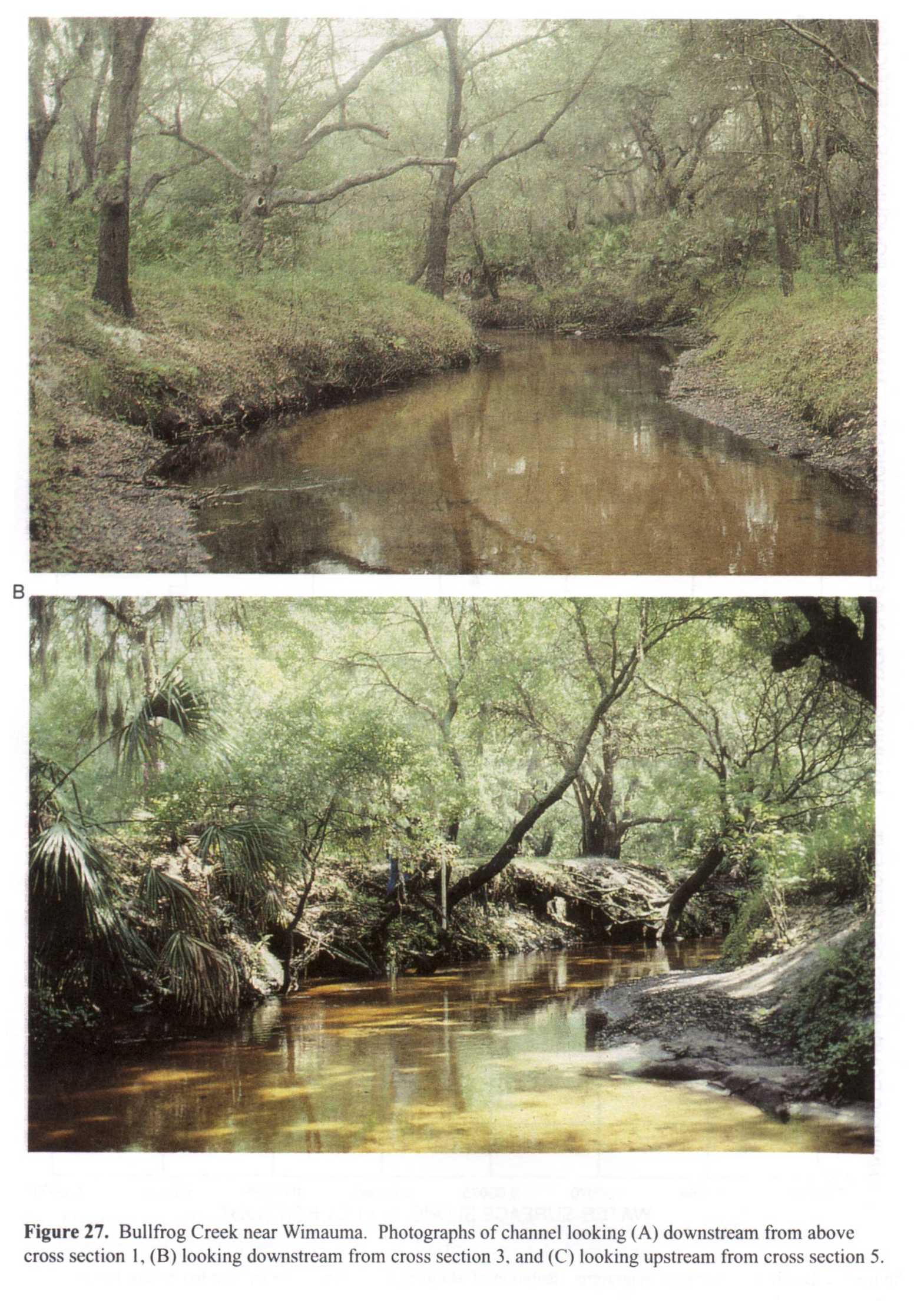
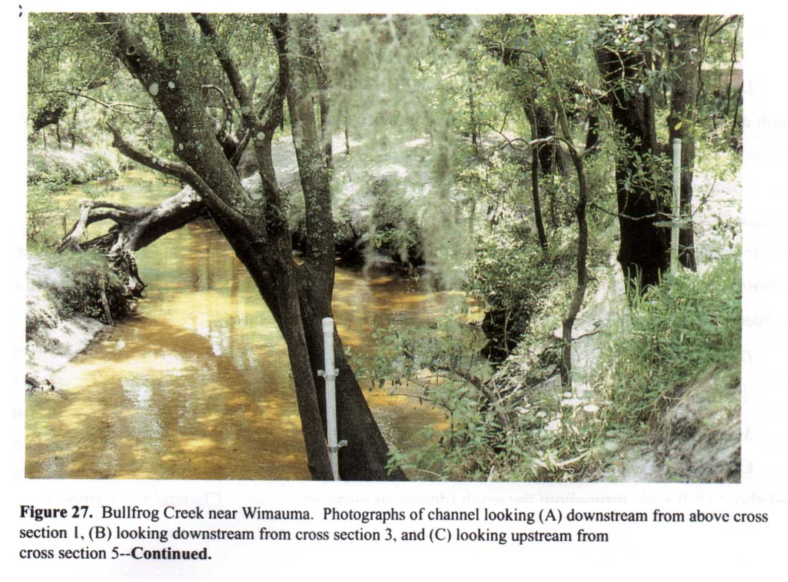
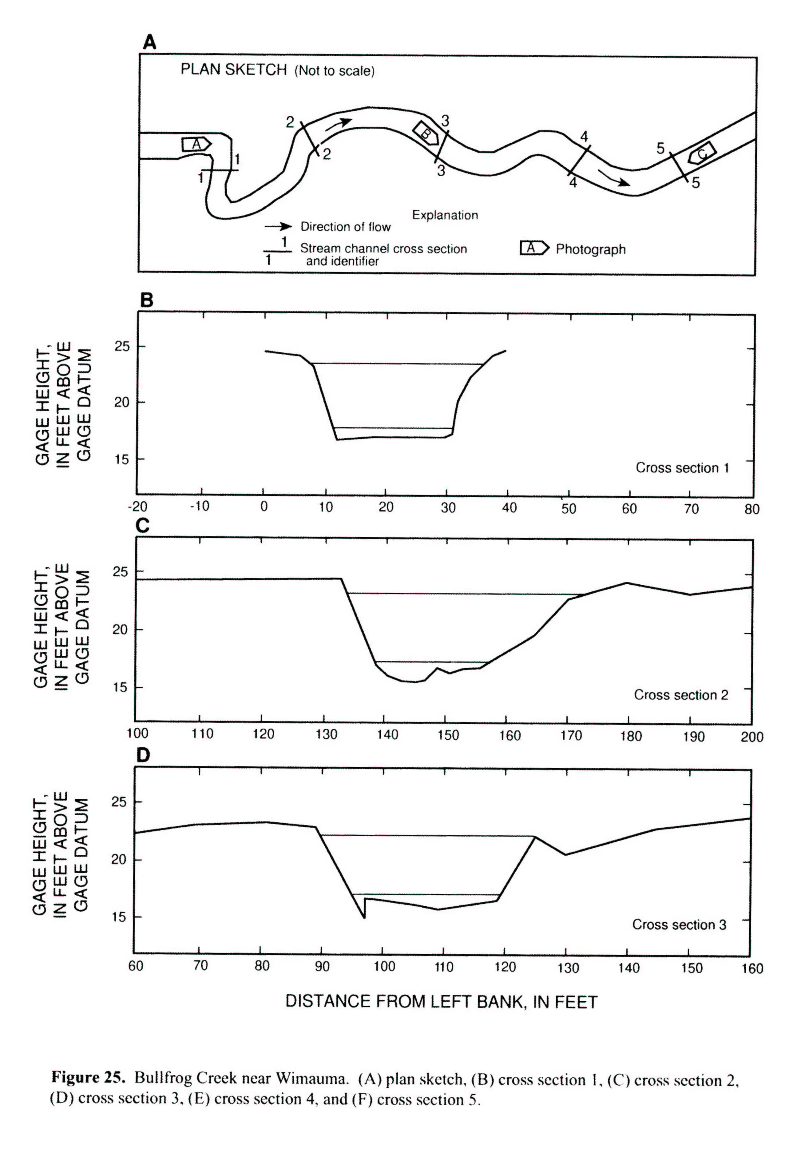
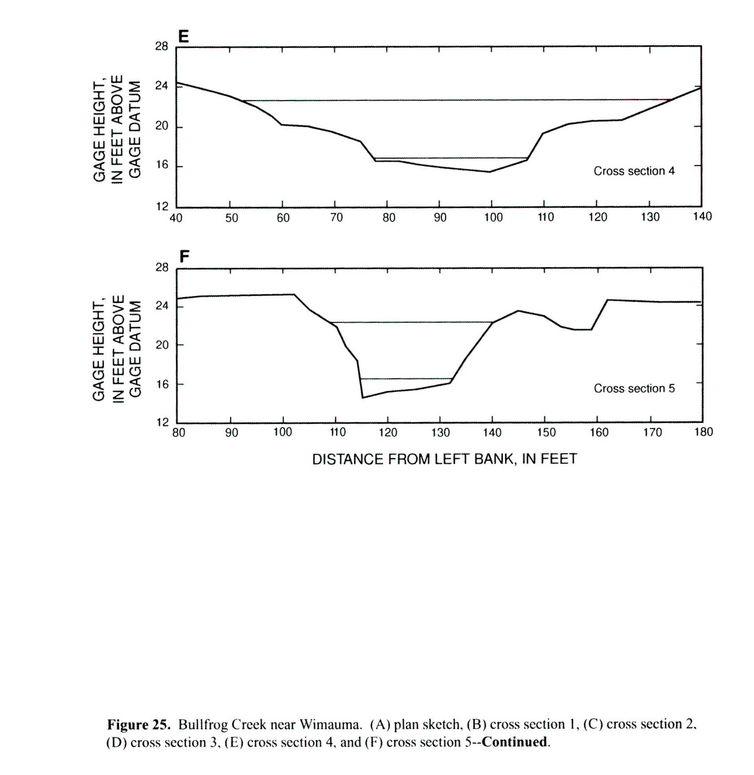 Location
.-- Lat 27°47'30", long 82°21'08", near Wimauma, Florida.
Description of channel.--
d50 = 0 mm.
d84 = 0 mm.
| Date of observation | Average depth (ft) | Average surface width (ft) | Discharge (ft3/s) | Average cross section area (ft2) | Hydraulic radius (ft) | Mean velocity (ft/s) | Slope | Coefficient of roughness n |
|---|
| Mar. 13, 1993 |
--- |
--- |
356.0 |
211.0 |
4.00 |
1.820 |
0.000740 |
0.059 |
| Apr. 16, 1993 |
--- |
--- |
264.0 |
163.0 |
3.79 |
1.710 |
0.000720 |
0.062 |
| June 08, 1992 |
--- |
--- |
216.0 |
131.0 |
3.28 |
1.730 |
0.000820 |
0.058 |
| Apr. 25, 1992 |
--- |
--- |
142.0 |
90.8 |
2.72 |
1.610 |
0.000630 |
0.055 |
| Jan. 09, 1993 |
--- |
--- |
141.0 |
95.1 |
2.79 |
1.530 |
0.000800 |
0.057 |
| June 16, 1992 |
--- |
--- |
19.0 |
21.0 |
0.90 |
0.930 |
0.000830 |
0.045 |
| Nov. 16, 1992 |
--- |
--- |
11.0 |
14.7 |
0.67 |
0.780 |
0.000910 |
0.047 |
02301750 Delaney Creek near Tampa, Fla.
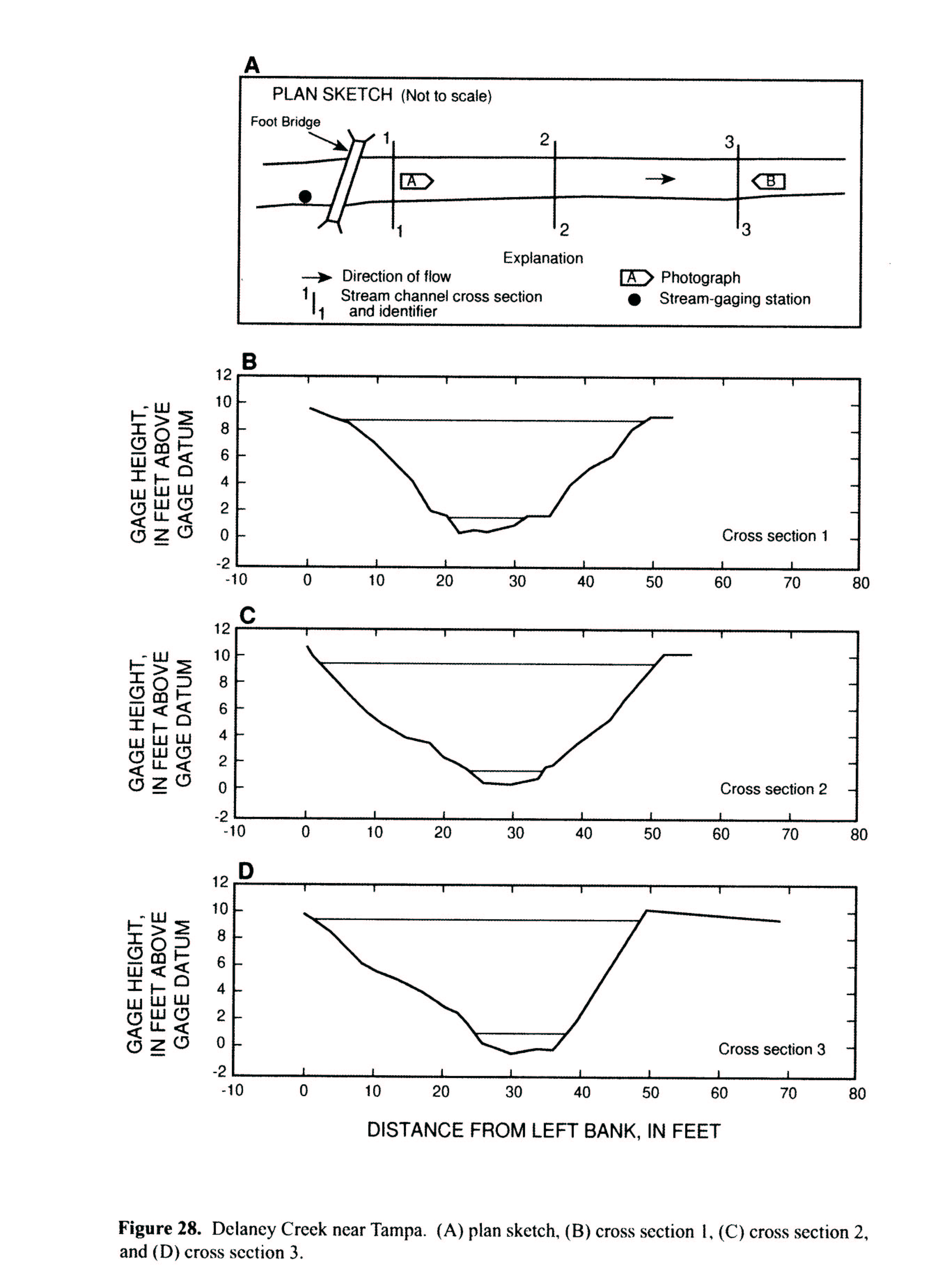
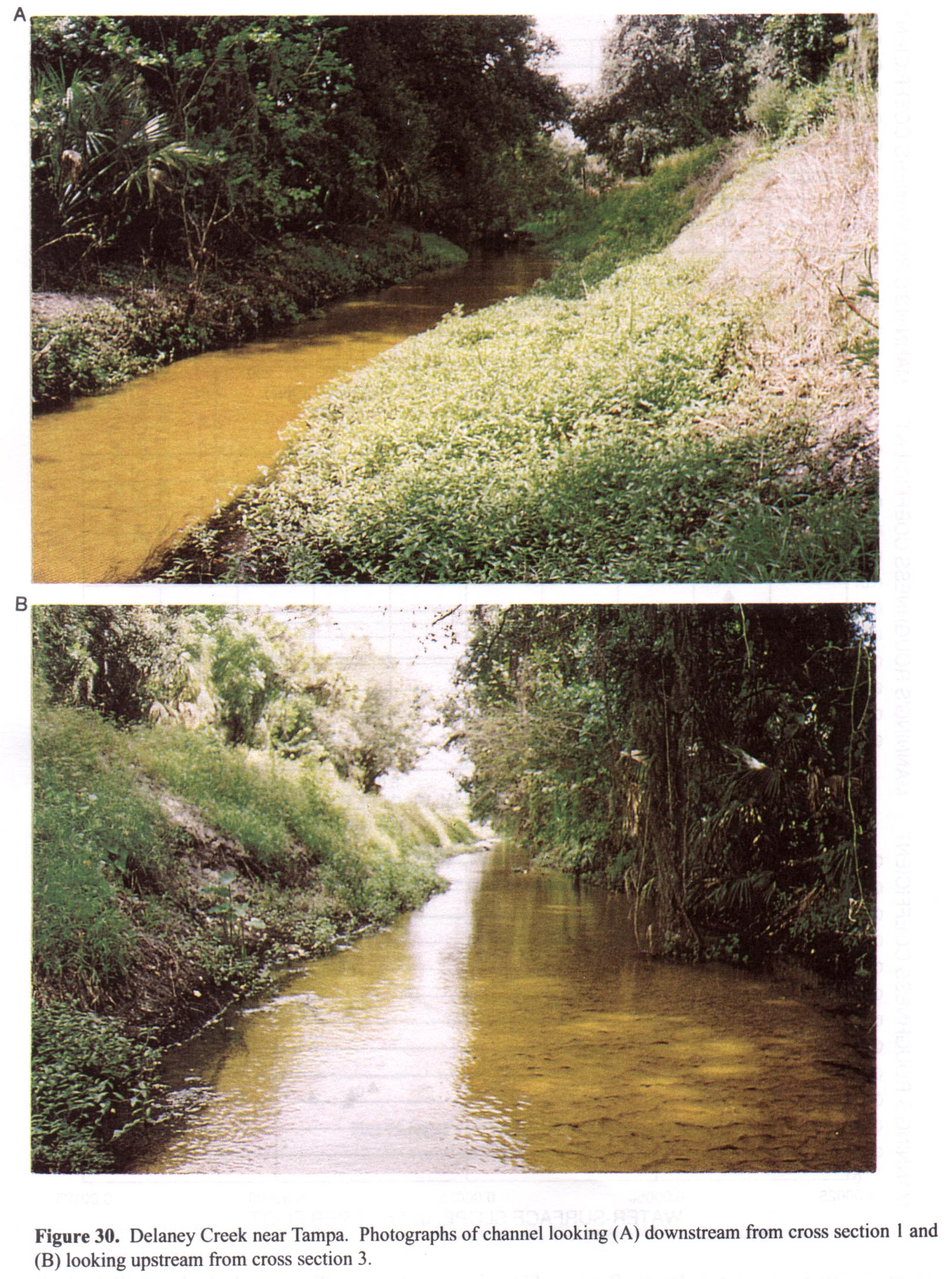 Location
.-- Lat 27°55'32", long 82°21'52", near Tampa, Florida.
Description of channel.--
d50 = 0 mm.
d84 = 0 mm.
| Date of observation | Average depth (ft) | Average surface width (ft) | Discharge (ft3/s) | Average cross section area (ft2) | Hydraulic radius (ft) | Mean velocity (ft/s) | Slope | Coefficient of roughness n |
|---|
| June 28, 1992 |
--- |
--- |
496.0 |
224.0 |
4.56 |
2.220 |
0.000570 |
0.045 |
| Sept. 06, 1993 |
--- |
--- |
222.0 |
113.0 |
3.09 |
1.970 |
0.000300 |
0.028 |
| Sept. 04, 1992 |
--- |
--- |
119.0 |
67.0 |
2.40 |
1.790 |
0.000290 |
0.024 |
| Sept. 28, 1994 |
--- |
--- |
80.0 |
42.0 |
1.90 |
1.940 |
0.001000 |
0.035 |
| Sept. 27, 1994 |
--- |
--- |
76.0 |
39.8 |
1.84 |
1.940 |
0.000900 |
0.032 |
| Oct. 03, 1992 |
--- |
--- |
37.0 |
22.9 |
1.29 |
1.670 |
0.000910 |
0.029 |
| Aug. 17, 1993 |
--- |
--- |
31.0 |
21.5 |
1.24 |
1.520 |
0.000950 |
0.031 |
| Oct. 06, 1992 |
--- |
--- |
20.0 |
15.7 |
1.00 |
1.390 |
0.001050 |
0.032 |
| Sept. 16, 1992 |
--- |
--- |
11.0 |
12.2 |
0.84 |
1.000 |
0.000870 |
0.035 |
| Feb. 05, 1993 |
--- |
--- |
5.6 |
10.0 |
0.75 |
0.630 |
0.001030 |
0.055 |
| Sept. 28, 1992 |
--- |
--- |
4.7 |
10.1 |
0.77 |
0.530 |
0.000910 |
0.063 |
| Sept. 22, 1992 |
--- |
--- |
4.4 |
9.8 |
0.77 |
0.510 |
0.000900 |
0.065 |
| Apr. 26, 1993 |
--- |
--- |
1.8 |
6.4 |
0.56 |
0.350 |
0.001020 |
0.080 |
| Oct. 23, 1992 |
--- |
--- |
1.8 |
7.8 |
0.65 |
0.270 |
0.000980 |
0.112 |
02303205 Baker Creek at McIntosh Road near Antioch, Fla.
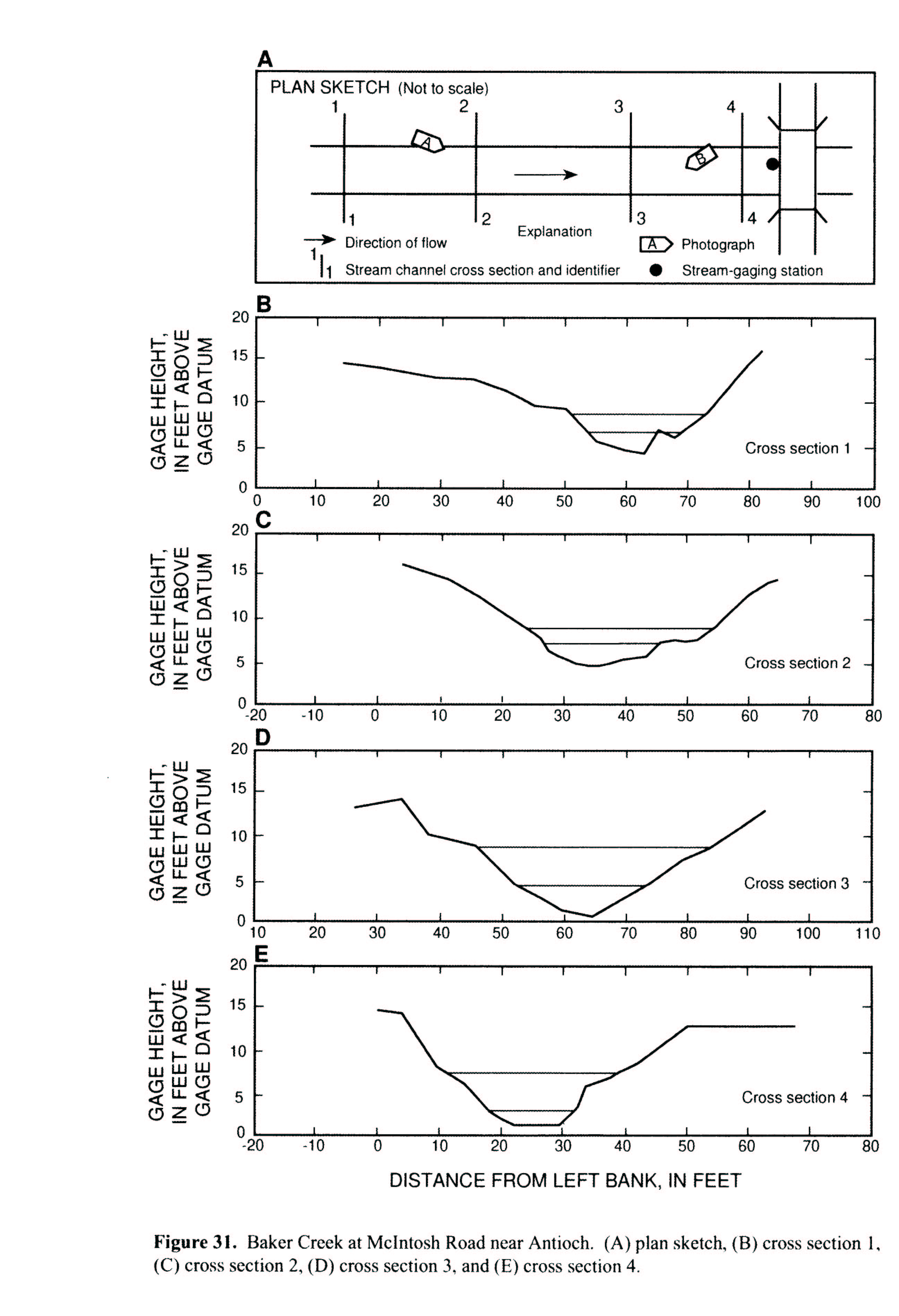
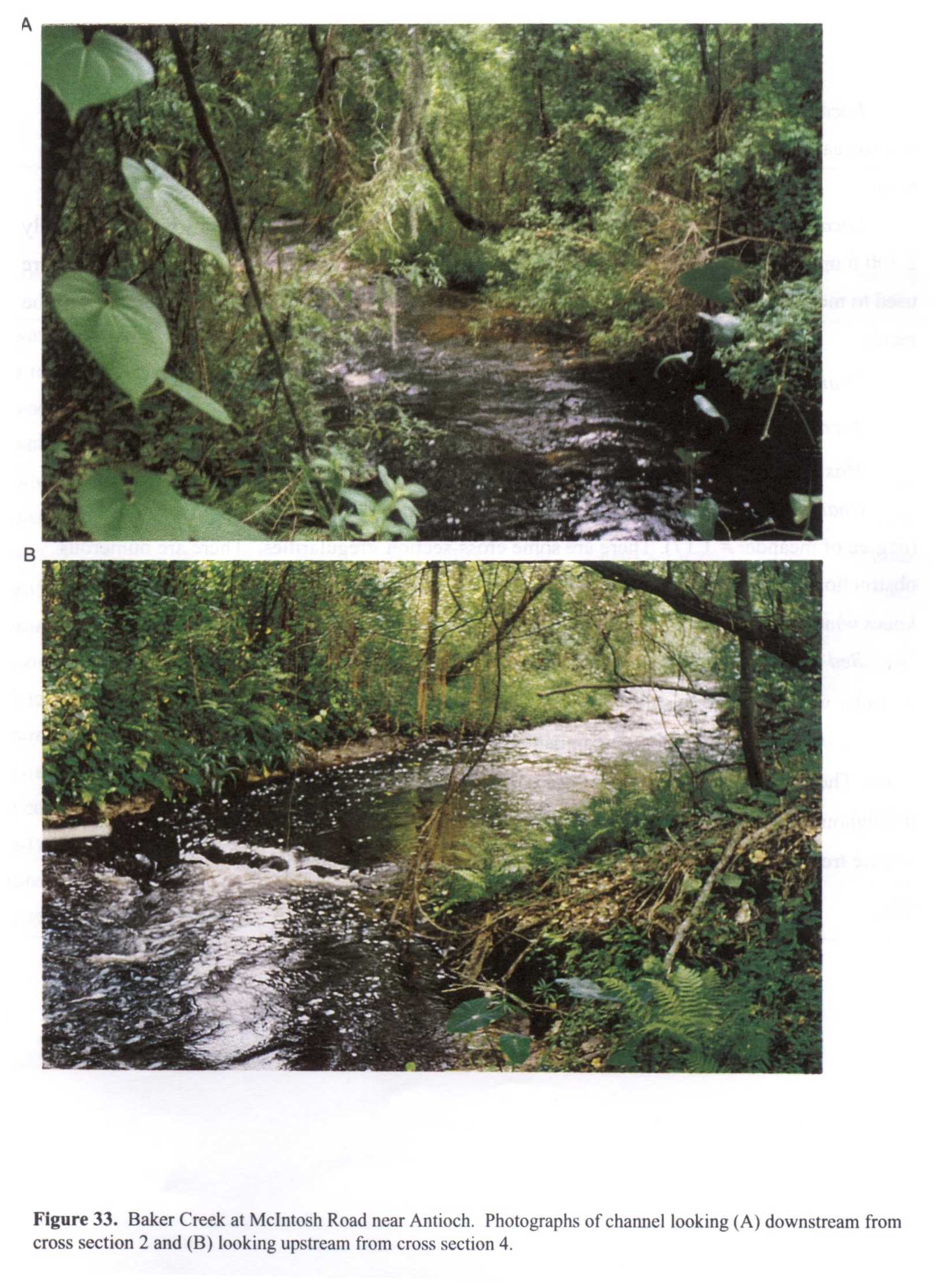 Location
.-- Lat 28°01'41", long 82°14'41", near Antioch, Florida.
Description of channel.--
d50 = 0 mm.
d84 = 0 mm.
| Date of observation | Average depth (ft) | Average surface width (ft) | Discharge (ft3/s) | Average cross section area (ft2) | Hydraulic radius (ft) | Mean velocity (ft/s) | Slope | Coefficient of roughness n |
|---|
| Aug. 30, 1994 |
--- |
--- |
310.0 |
108.0 |
3.10 |
3.120 |
0.002230 |
0.051 |
| Oct. 03, 1992 |
--- |
--- |
151.0 |
57.9 |
2.34 |
3.020 |
0.003240 |
0.058 |
| Aug. 27, 1993 |
--- |
--- |
128.0 |
49.3 |
2.13 |
2.880 |
0.004760 |
0.066 |
| Sept. 06, 1993 |
--- |
--- |
81.0 |
40.6 |
1.88 |
2.140 |
0.004270 |
0.095 |
| Aug. 28, 1993 |
--- |
--- |
78.0 |
37.3 |
1.78 |
2.230 |
0.004150 |
0.088 |
| Sept. 07, 1993 |
--- |
--- |
51.0 |
30.0 |
1.54 |
1.790 |
0.004240 |
0.108 |
| Aug. 25, 1994 |
--- |
--- |
43.0 |
28.0 |
1.47 |
1.630 |
0.004510 |
0.118 |
02310000 Anclote River near Elfers, Fla.
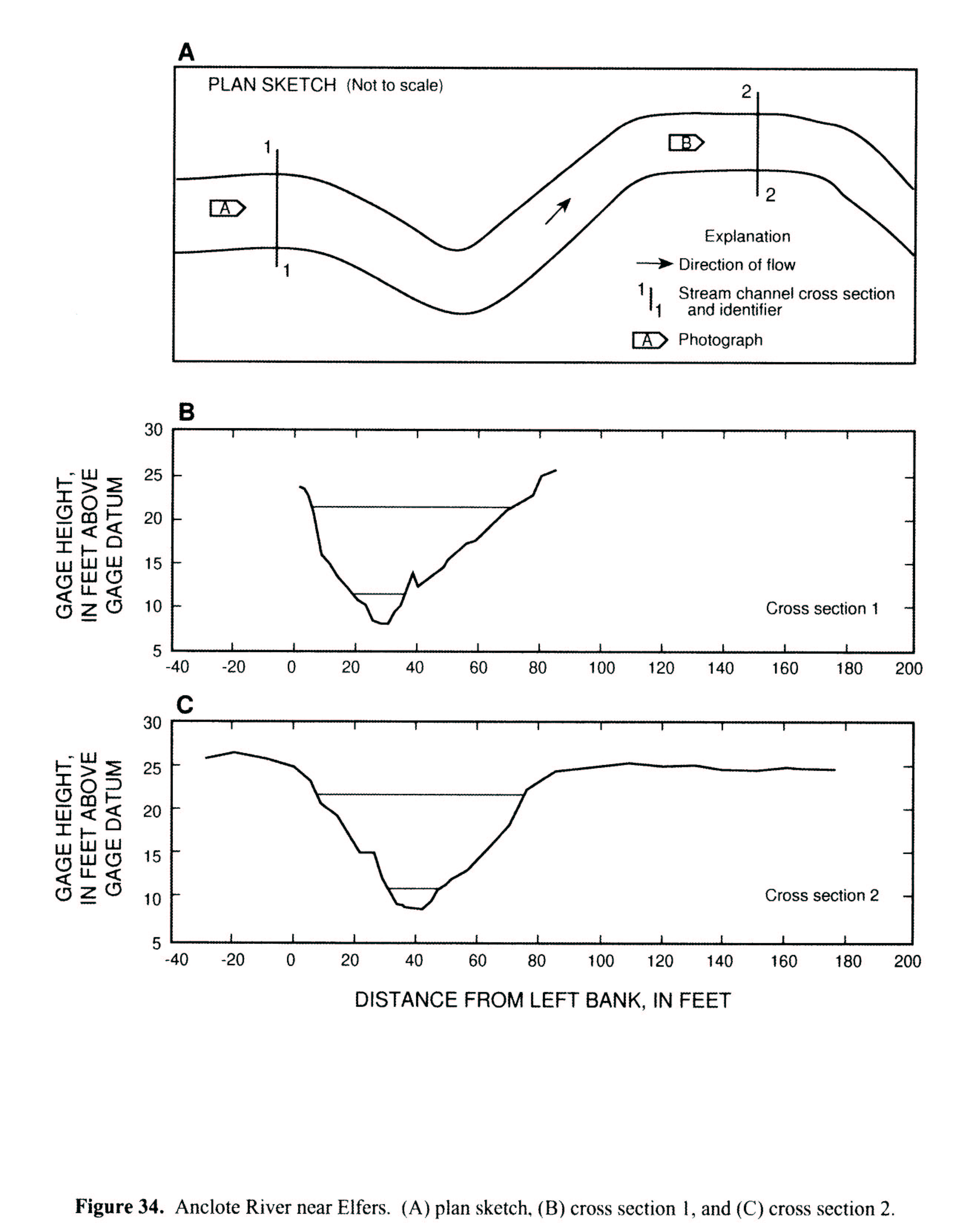
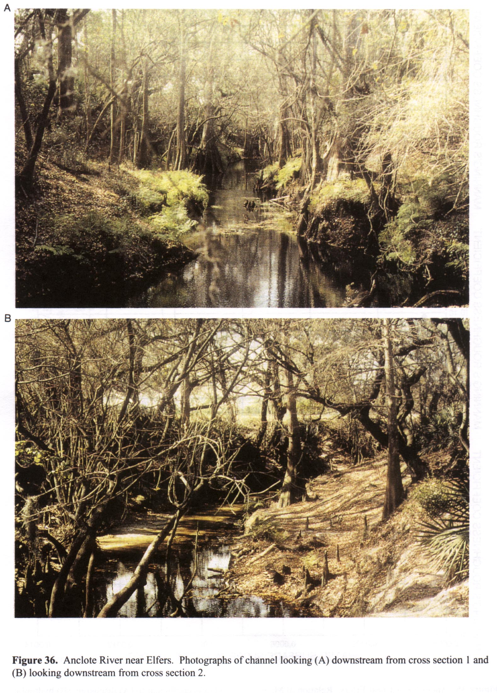 Location
.-- Lat 28°12'50", long 82°40'00", near Elfers, Florida.
Description of channel.--
d50 = 0 mm.
d84 = 0 mm.
| Date of observation | Average depth (ft) | Average surface width (ft) | Discharge (ft3/s) | Average cross section area (ft2) | Hydraulic radius (ft) | Mean velocity (ft/s) | Slope | Coefficient of roughness n |
|---|
| Oct. 05, 1992 |
--- |
--- |
782.0 |
458.0 |
6.23 |
1.710 |
0.000520 |
0.066 |
| Sept. 10, 1992 |
--- |
--- |
274.0 |
194.0 |
3.85 |
1.420 |
0.000720 |
0.068 |
| Sept. 06, 1992 |
--- |
--- |
209.0 |
153.0 |
3.32 |
1.380 |
0.000880 |
0.070 |
| Sept. 01, 1992 |
--- |
--- |
173.0 |
128.0 |
3.16 |
1.360 |
0.000680 |
0.060 |
| Sept. 10, 1993 |
--- |
--- |
152.0 |
118.0 |
3.02 |
1.310 |
0.000840 |
0.069 |
| Sept. 15, 1992 |
--- |
--- |
107.0 |
94.8 |
2.64 |
1.160 |
0.001240 |
0.086 |
| Mar. 15, 1993 |
--- |
--- |
100.0 |
89.2 |
2.54 |
1.140 |
0.000740 |
0.066 |
| Apr. 17, 1993 |
--- |
--- |
76.0 |
72.0 |
2.31 |
1.080 |
0.000780 |
0.067 |
| Apr. 16, 1993 |
--- |
--- |
67.0 |
63.3 |
2.22 |
1.070 |
0.000660 |
0.060 |
| Apr. 01, 1993 |
--- |
--- |
54.0 |
61.4 |
2.19 |
0.900 |
0.000720 |
0.075 |
| Nov. 12, 1992 |
--- |
--- |
54.0 |
54.9 |
2.10 |
1.000 |
0.000880 |
0.072 |
| Oct. 16, 1992 |
--- |
--- |
43.0 |
47.0 |
1.98 |
0.940 |
0.000880 |
0.074 |
| Jan. 18, 1993 |
--- |
--- |
39.0 |
43.5 |
1.92 |
0.920 |
0.000780 |
0.069 |
| Nov. 20, 1992 |
--- |
--- |
19.0 |
30.5 |
1.64 |
0.660 |
0.000860 |
0.093 |
| Dec. 17, 1992 |
--- |
--- |
12.0 |
22.6 |
1.34 |
0.580 |
0.000640 |
0.081 |
| Feb. 06, 1993 |
--- |
--- |
11.0 |
21.9 |
1.32 |
0.530 |
0.000880 |
0.098 |
| Oct. 29, 1992 |
--- |
--- |
8.0 |
19.7 |
1.23 |
0.430 |
0.000840 |
0.122 |
02312720 Withlacoochee River at Wysong Dam at Carlson, Fla.
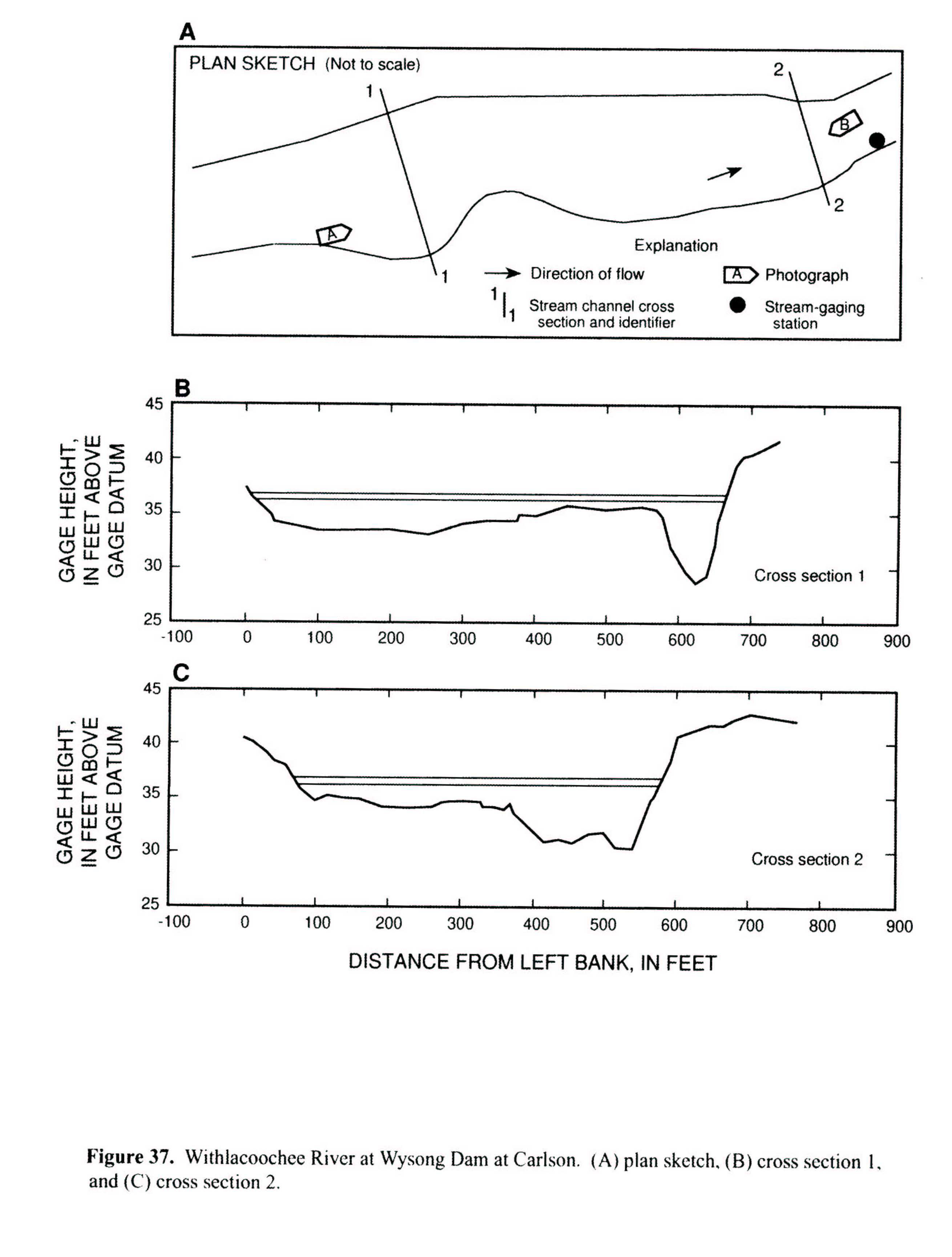
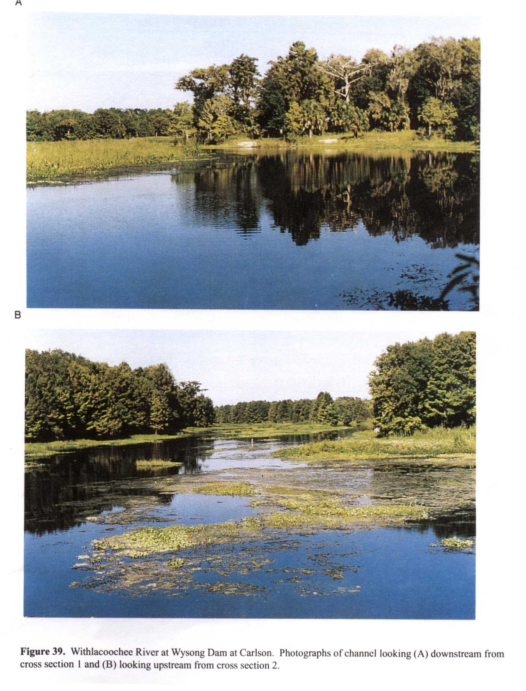 Location
.-- Lat 28°49'23", long 82°11'00", near Carlson, Florida.
Description of channel.--
d50 = 0 mm.
d84 = 0 mm.
| Date of observation | Average depth (ft) | Average surface width (ft) | Discharge (ft3/s) | Average cross section area (ft2) | Hydraulic radius (ft) | Mean velocity (ft/s) | Slope | Coefficient of roughness n |
|---|
| Oct. 15, 1992 |
--- |
--- |
352.0 |
1890.0 |
3.22 |
0.190 |
0.000050 |
0.117 |
| Sept. 28, 1993 |
--- |
--- |
332.0 |
1970.0 |
3.34 |
0.170 |
0.000070 |
0.157 |
| Oct. 08, 1992 |
--- |
--- |
321.0 |
1830.0 |
3.12 |
0.180 |
0.000060 |
0.139 |
| Mar. 17, 1993 |
--- |
--- |
313.0 |
1980.0 |
3.36 |
0.160 |
0.000050 |
0.148 |
| Feb. 02, 1993 |
--- |
--- |
284.0 |
1720.0 |
2.96 |
0.170 |
0.000050 |
0.125 |
| Aug. 02, 1993 |
--- |
--- |
282.0 |
1720.0 |
2.96 |
0.170 |
0.000030 |
0.097 |
| Dec. 04, 1992 |
--- |
--- |
249.0 |
1680.0 |
2.89 |
0.150 |
0.000040 |
0.122 |
| Nov. 19, 1992 |
--- |
--- |
232.0 |
1600.0 |
2.77 |
0.150 |
0.000020 |
0.086 |
| Dec. 18, 1992 |
--- |
--- |
226.0 |
1490.0 |
2.76 |
0.150 |
0.000020 |
0.098 |
| Aug. 26, 1993 |
--- |
--- |
200.0 |
1490.0 |
2.59 |
0.140 |
0.000050 |
0.146 |
| June 03, 1993 |
--- |
--- |
169.0 |
1630.0 |
2.81 |
0.110 |
0.000030 |
0.161 |


